Hatfield geodata
Hatfield (England) is a populated place; located in United Kingdom in Europe/London (GMT+1) time zone. With population of 41,677 people, there are 288 cities with bigger population in this country. Compared to other cities in United Kingdom, 68.9% of cities are located further ↑North; 82.4% of cities are located further ←West and 64% of cities have lower elevation than Hatfield. Note1
Administrative division(s):
- Level 1: England
- Level 2: Hertfordshire
- Level 3: Welwyn Hatfield
- Level 4: Hatfield


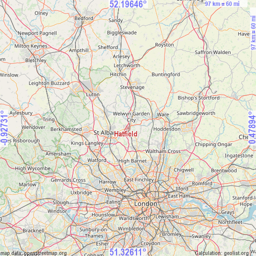
Hatfield GPS coordinates[2]
51° 45' 48.168" North, 0° 13' 27.084" West
| Map corner | latitude | longitude |
|---|---|---|
| Upper-left | 52.19646°, | -0.92731° |
| Center: | 51.76338°, | -0.22419° |
| Lower-right: | 51.32611°, | 0.47894° |
| Map W x H: | 96.8×96.8 km | = 60.1×60.1mi |
| max Lat: | 60.39635° ⇑68.9% North |
| Hatfield: | 51.76338° |
| min Lat: | ⇓31.1% South 34.60088° |
| min Long | Hatfield | max Long |
| -7.64133° | -0.22419° | 32.95536° |
| W 82.4%⇐ | ⇒17.6% E |
Elevation
Elevation of Hatfield is 84 m = 276 ft, and this is 11.1 m = 36 ft above average elevation for this country.
| Max E: |
515 m = 1690 ft | 36% |
| Hatfield | 84 m 276 ft | |
| Avg. | 72.9 m = 239 ft | |
Min E: |
-30 m = -98 ft | 64% |
See also: Hatfield elevation on elevation.city.
Geographical zone
Hatfield is located in North temperate zone (between Tropic of Cancer and the Arctic Circle). Distance of this North polar circle is 1645.6 km =1022.5 mi to North.| Distance of | km | miles | from Hatfield |
|---|---|---|---|
| North Pole | 4251.5 | 2641.8 | to North |
| Arctic Circle | 1645.6 | 1022.5 | to North |
| Tropic Cancer | 3149.6 | 1957.1 | to South |
| Equator | 5755.5 | 3576.3 | to South |


Nearby cities:
15 places around Hatfield: (largest is in red/bold)
• Codicote
9.7 km =6 mi,  354°
354°
• Cuffley
9.9 km =6.2 mi,  128°
128°
• Datchworth
10.7 km =6.6 mi,  24°
24°
• Essendon
4.8 km =3 mi,  90°
90°
• Hertford
10.7 km =6.6 mi,  70°
70°
• Northaw
8.5 km =5.3 mi,  141°
141°
• Potters Bar
8.4 km =5.2 mi,  157°
157°
• Radlett
10.8 km =6.7 mi,  217°
217°
• Shenley
9 km =5.6 mi,  205°
205°
• South Mimms
7.5 km =4.7 mi,  184°
184°
• St Albans
7.7 km =4.8 mi,  258°
258°
• Tewin
7.5 km =4.7 mi,  38°
38°
• Welwyn
7.8 km =4.8 mi,  5°
5°
• Welwyn Garden City
4.4 km =2.7 mi, 15°
• Wheathampstead
7.2 km =4.5 mi,  318°
318°
Sources, notices
• [Note1] Compared only with cities in United Kingdom existing in our database
• [Src1] Map data: © OpenStreetMap contributors (CC-BY-SA)
• [Src2] Other city data from geonames.org with taken over terms of usage.
• [Src3] Geographical zone / Annual Mean Temperature by Robert A. Rohde @ Wikipedia
