Harrogate geodata
Harrogate (England) is a populated place; located in United Kingdom in Europe/London (GMT+1) time zone. With population of 89,060 people, there are 113 cities with bigger population in this country. Compared to other cities in United Kingdom, 78.4% of cities are located further ↓South; 54.6% of cities are located further ←West and 83.1% of cities have lower elevation than Harrogate. Note1


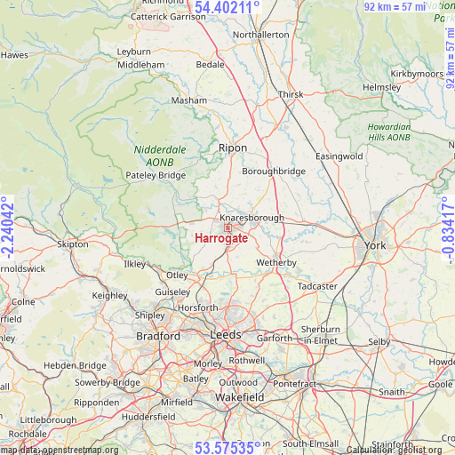
Harrogate GPS coordinates[2]
53° 59' 26.808" North, 1° 32' 14.28" West
| Map corner | latitude | longitude |
|---|---|---|
| Upper-left | 54.40211°, | -2.24042° |
| Center: | 53.99078°, | -1.5373° |
| Lower-right: | 53.57535°, | -0.83417° |
| Map W x H: | 91.9×91.9 km | = 57.1×57.1mi |
| max Lat: | 60.39635° ⇑21.6% North |
| Harrogate: | 53.99078° |
| min Lat: | ⇓78.4% South 34.60088° |
| min Long | Harrogate | max Long |
| -7.64133° | -1.5373° | 32.95536° |
| W 54.6%⇐ | ⇒45.4% E |
Elevation
Elevation of Harrogate is 127 m = 417 ft, and this is 54.1 m = 177 ft above average elevation for this country.
| Max E: |
515 m = 1690 ft | 16.9% |
| Harrogate | 127 m 417 ft | |
| Avg. | 72.9 m = 239 ft | |
Min E: |
-30 m = -98 ft | 83.1% |
See also: Harrogate elevation on elevation.city.
Geographical zone
Harrogate is located in North temperate zone (between Tropic of Cancer and the Arctic Circle). Distance of this North polar circle is 1398 km =868.7 mi to North.| Distance of | km | miles | from Harrogate |
|---|---|---|---|
| North Pole | 4003.8 | 2487.8 | to North |
| Arctic Circle | 1398 | 868.7 | to North |
| Tropic Cancer | 3397.3 | 2111 | to South |
| Equator | 6003.2 | 3730.2 | to South |


Nearby cities:
15 places around Harrogate: (largest is in red/bold)
• Bardsey
13.2 km =8.2 mi,  152°
152°
• Bishop Monkton
11.7 km =7.3 mi,  13°
13°
• Bramhope
12.9 km =8 mi,  203°
203°
• Burton Leonard
9 km =5.6 mi,  15°
15°
• Collingham
12 km =7.5 mi,  136°
136°
• Darley
11.6 km =7.2 mi,  293°
293°
• East Keswick
12.1 km =7.5 mi, 152°
• Hampsthwaite
5.8 km =3.6 mi,  309°
309°
• Knaresborough
4.9 km =3 mi,  65°
65°
• Otley
14 km =8.7 mi,  227°
227°
• Pannal
3.4 km =2.1 mi,  178°
178°
• Pool
11.4 km =7.1 mi,  207°
207°
• Spofforth
7.1 km =4.4 mi,  124°
124°
• Stainburn
8.2 km =5.1 mi,  219°
219°
• Wetherby
12.1 km =7.5 mi,  125°
125°
Sources, notices
• [Note1] Compared only with cities in United Kingdom existing in our database
• [Src1] Map data: © OpenStreetMap contributors (CC-BY-SA)
• [Src2] Other city data from geonames.org with taken over terms of usage.
• [Src3] Geographical zone / Annual Mean Temperature by Robert A. Rohde @ Wikipedia
