Harlow geodata
Harlow (England) is a populated place; located in United Kingdom in Europe/London (GMT+0) time zone. With population of 94,365 people, there are 104 cities with bigger population in this country. Compared to other cities in United Kingdom, 68.6% of cities are located further ↑North; 88.1% of cities are located further ←West and 54.7% of cities have lower elevation than Harlow. Note1


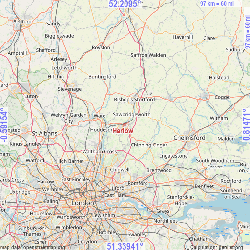
Harlow GPS coordinates[2]
51° 46' 35.58" North, 0° 6' 41.688" East
| Map corner | latitude | longitude |
|---|---|---|
| Upper-left | 52.2095°, | -0.59154° |
| Center: | 51.77655°, | 0.11158° |
| Lower-right: | 51.33941°, | 0.81471° |
| Map W x H: | 96.7×96.7 km | = 60.1×60.1mi |
| max Lat: | 60.39635° ⇑68.6% North |
| Harlow: | 51.77655° |
| min Lat: | ⇓31.4% South 34.60088° |
| min Long | Harlow | max Long |
| -7.64133° | 0.11158° | 32.95536° |
| W 88.1%⇐ | ⇒11.9% E |
Elevation
Elevation of Harlow is 68 m = 223 ft, and this is 4.9 m = 16 ft below average elevation for this country.
| Max E: |
515 m = 1690 ft | 45.3% |
| Avg. | 72.9 m = 239 ft | |
| Harlow | 68 m = 223 ft | |
Min E: |
-30 m = -98 ft | 54.7% |
See also: Harlow elevation on elevation.city.
Geographical zone
Harlow is located in North temperate zone (between Tropic of Cancer and the Arctic Circle). Distance of this North polar circle is 1644.2 km =1021.7 mi to North.| Distance of | km | miles | from Harlow |
|---|---|---|---|
| North Pole | 4250 | 2640.8 | to North |
| Arctic Circle | 1644.2 | 1021.7 | to North |
| Tropic Cancer | 3151.1 | 1958 | to South |
| Equator | 5757 | 3577.2 | to South |


Nearby cities:
15 places around Harlow: (largest is in red/bold)
• Broxbourne
9.6 km =6 mi,  250°
250°
• Epping
8.7 km =5.4 mi,  180°
180°
• Great Amwell
9 km =5.6 mi,  279°
279°
• Hastingwood
4.2 km =2.6 mi,  139°
139°
• Hatfield Heath
8 km =5 mi,  60°
60°
• Hoddesdon
8.6 km =5.3 mi,  258°
258°
• Little Amwell
10 km =6.2 mi,  274°
274°
• Little Hallingbury
7.9 km =4.9 mi,  37°
37°
• Much Hadham
9 km =5.6 mi,  342°
342°
• Old Harlow
1.7 km =1.1 mi, 63°
• Roydon
4.9 km =3 mi, 263°
• Sawbridgeworth
5.2 km =3.2 mi,  30°
30°
• Sheering
5.9 km =3.7 mi, 58°
• Ware
10.4 km =6.5 mi,  291°
291°
• Widford
6.3 km =3.9 mi,  325°
325°
Sources, notices
• [Note1] Compared only with cities in United Kingdom existing in our database
• [Src1] Map data: © OpenStreetMap contributors (CC-BY-SA)
• [Src2] Other city data from geonames.org with taken over terms of usage.
• [Src3] Geographical zone / Annual Mean Temperature by Robert A. Rohde @ Wikipedia
