Sixpenny Handley geodata
Sixpenny Handley (England) is a populated place; located in United Kingdom in Europe/London (GMT+1) time zone. With population of 906 people, there are 3799 cities with bigger population in this country. Compared to other cities in United Kingdom, 92.3% of cities are located further ↑North; 54.8% of cities are located further →East and 64% of cities have lower elevation than Sixpenny Handley. Note1
Administrative division(s):
- Level 1: England
- Level 2: Dorset
- Level 3: East Dorset District
- Level 4: Sixpenny Handley


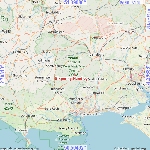
Sixpenny Handley GPS coordinates[2]
50° 57' 0" North, 2° 0' 0" West
| Map corner | latitude | longitude |
|---|---|---|
| Upper-left | 51.39086°, | -2.70313° |
| Center: | 50.95°, | -2° |
| Lower-right: | 50.50492°, | -1.29688° |
| Map W x H: | 98.5×98.5 km | = 61.2×61.2mi |
| max Lat: | 60.39635° ⇑92.3% North |
| Sixpenny Handley: | 50.95° |
| min Lat: | ⇓7.7% South 34.60088° |
| min Long | Sixpenny Handle | max Long |
| -7.64133° | -2° | 32.95536° |
| W 45.2%⇐ | ⇒54.8% E |
Elevation
Elevation of Sixpenny Handley is 84 m = 276 ft, and this is 11.1 m = 36 ft above average elevation for this country.
| Max E: |
515 m = 1690 ft | 36% |
| Sixpenny Handley | 84 m 276 ft | |
| Avg. | 72.9 m = 239 ft | |
Min E: |
-30 m = -98 ft | 64% |
See also: United Kingdom elevation on elevation.city.
Geographical zone
Sixpenny Handley is located in North temperate zone (between Tropic of Cancer and the Arctic Circle). Distance of this North polar circle is 1736.1 km =1078.8 mi to North.| Distance of | km | miles | from Sixpenny Handley |
|---|---|---|---|
| North Pole | 4342 | 2698 | to North |
| Arctic Circle | 1736.1 | 1078.8 | to North |
| Tropic Cancer | 3059.2 | 1900.9 | to South |
| Equator | 5665.1 | 3520.1 | to South |


Nearby cities:
15 places around Sixpenny Handley: (largest is in red/bold)
• Alderholt
12.6 km =7.8 mi,  109°
109°
• Ansty
10.6 km =6.6 mi,  335°
335°
• Bishopstone
11.2 km =7 mi,  37°
37°
• Bower Chalke
6 km =3.7 mi,  22°
22°
• Broad Chalke
9.3 km =5.8 mi, 22°
• Cranborne
6.5 km =4 mi,  121°
121°
• Dinton
14.9 km =9.3 mi,  4°
4°
• Fordingbridge
14.9 km =9.3 mi,  99°
99°
• Fovant
11.8 km =7.3 mi, 2°
• Iwerne Minster
13.6 km =8.5 mi,  259°
259°
• Pimperne
12.1 km =7.5 mi,  232°
232°
• Shaftesbury
14.9 km =9.3 mi,  294°
294°
• Three Legged Cross
13.8 km =8.6 mi,  143°
143°
• Tisbury
13.8 km =8.6 mi, 335°
• Verwood
12.3 km =7.6 mi,  132°
132°
Sources, notices
• [Note1] Compared only with cities in United Kingdom existing in our database
• [Src1] Map data: © OpenStreetMap contributors (CC-BY-SA)
• [Src2] Other city data from geonames.org with taken over terms of usage.
• [Src3] Geographical zone / Annual Mean Temperature by Robert A. Rohde @ Wikipedia
