Halesworth geodata
Halesworth (England) is a populated place; located in United Kingdom in Europe/London (GMT+1) time zone. With population of 5,558 people, there are 1536 cities with bigger population in this country. Compared to other cities in United Kingdom, 52.9% of cities are located further ↑North; 99.4% of cities are located further ←West and 79% of cities have higher elevation than Halesworth. Note1
Administrative division(s):
- Level 1: England
- Level 2: Suffolk
- Level 3: Waveney District
- Level 4: Halesworth


Halesworth GPS coordinates[2]
52° 20' 47.04" North, 1° 30' 10.44" East
| Map corner | latitude | longitude |
|---|---|---|
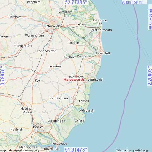
| Upper-left | 52.77385°, | 0.79978° |
| Center: | 52.3464°, | 1.5029° |
| Lower-right: | 51.91478°, | 2.20603° |
| Map W x H: | 95.5×95.5 km | = 59.3×59.3mi |
| max Lat: | 60.39635° ⇑52.9% North |
| Halesworth: | 52.3464° |
| min Lat: | ⇓47.1% South 34.60088° |
| min Long | Halesworth | max Long |
| -7.64133° | 1.5029° | 32.95536° |
| W 99.4%⇐ | ⇒0.59999999999999% E |
Elevation
Elevation of Halesworth is 22 m = 72 ft, and this is 50.9 m = 167 ft below average elevation for this country.
| Max E: |
515 m = 1690 ft | 79% |
| Avg. | 72.9 m = 239 ft | |
| Halesworth | 22 m = 72 ft | |
Min E: |
-30 m = -98 ft | 21% |
See also: United Kingdom elevation on elevation.city.
Geographical zone
Halesworth is located in North temperate zone (between Tropic of Cancer and the Arctic Circle). Distance of this North polar circle is 1580.8 km =982.3 mi to North.| Distance of | km | miles | from Halesworth |
|---|---|---|---|
| North Pole | 4186.7 | 2601.5 | to North |
| Arctic Circle | 1580.8 | 982.3 | to North |
| Tropic Cancer | 3214.5 | 1997.4 | to South |
| Equator | 5820.4 | 3616.6 | to South |


Nearby cities:
15 places around Halesworth: (largest is in red/bold)
• Barnby
14.7 km =9.1 mi,  39°
39°
• Beccles
13.2 km =8.2 mi,  18°
18°
• Bungay
12.8 km =8 mi,  339°
339°
• Cookley
4.9 km =3 mi,  227°
227°
• Ditchingham
14 km =8.7 mi, 343°
• Earsham
13 km =8.1 mi,  333°
333°
• Ellingham
15 km =9.3 mi,  356°
356°
• Fressingfield
12.6 km =7.8 mi,  270°
270°
• Harleston
15.4 km =9.6 mi,  294°
294°
• Laxfield
10.5 km =6.5 mi,  242°
242°
• Peasenhall
9.1 km =5.7 mi,  202°
202°
• Saxmundham
14.6 km =9.1 mi,  183°
183°
• Southwold
12.2 km =7.6 mi,  100°
100°
• Wrentham
11.9 km =7.4 mi,  69°
69°
• Yoxford
8.7 km =5.4 mi, 178°
Sources, notices
• [Note1] Compared only with cities in United Kingdom existing in our database
• [Src1] Map data: © OpenStreetMap contributors (CC-BY-SA)
• [Src2] Other city data from geonames.org with taken over terms of usage.
• [Src3] Geographical zone / Annual Mean Temperature by Robert A. Rohde @ Wikipedia
