Habrough geodata
Habrough (England) is a populated place; located in United Kingdom in Europe/London (GMT+1) time zone. With population of 631 people, there are 4489 cities with bigger population in this country. Compared to other cities in United Kingdom, 72% of cities are located further ↓South; 81.8% of cities are located further ←West and 84.7% of cities have higher elevation than Habrough. Note1


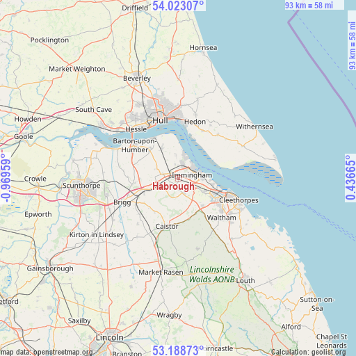
Habrough GPS coordinates[2]
53° 36' 28.656" North, 0° 15' 59.292" West
| Map corner | latitude | longitude |
|---|---|---|
| Upper-left | 54.02307°, | -0.96959° |
| Center: | 53.60796°, | -0.26647° |
| Lower-right: | 53.18873°, | 0.43665° |
| Map W x H: | 92.8×92.8 km | = 57.7×57.7mi |
| max Lat: | 60.39635° ⇑28% North |
| Habrough: | 53.60796° |
| min Lat: | ⇓72% South 34.60088° |
| min Long | Habrough | max Long |
| -7.64133° | -0.26647° | 32.95536° |
| W 81.8%⇐ | ⇒18.2% E |
Elevation
Elevation of Habrough is 16 m = 52 ft, and this is 56.9 m = 187 ft below average elevation for this country.
| Max E: |
515 m = 1690 ft | 84.7% |
| Avg. | 72.9 m = 239 ft | |
| Habrough | 16 m = 52 ft | |
Min E: |
-30 m = -98 ft | 15.3% |
See also: United Kingdom elevation on elevation.city.
Geographical zone
Habrough is located in North temperate zone (between Tropic of Cancer and the Arctic Circle). Distance of this North polar circle is 1440.5 km =895.1 mi to North.| Distance of | km | miles | from Habrough |
|---|---|---|---|
| North Pole | 4046.4 | 2514.3 | to North |
| Arctic Circle | 1440.5 | 895.1 | to North |
| Tropic Cancer | 3354.7 | 2084.5 | to South |
| Equator | 5960.6 | 3703.7 | to South |


Nearby cities:
15 places around Habrough: (largest is in red/bold)
• Barnetby le Wold
9.9 km =6.2 mi,  248°
248°
• Barrow upon Humber
10.6 km =6.6 mi,  314°
314°
• Bradley
10.9 km =6.8 mi,  126°
126°
• Croxton
5.5 km =3.4 mi,  256°
256°
• East Halton
6.2 km =3.9 mi,  351°
351°
• Goxhill
8.9 km =5.5 mi,  328°
328°
• Great Coates
9.4 km =5.8 mi,  116°
116°
• Healing
7.5 km =4.7 mi,  113°
113°
• Immingham
3 km =1.9 mi,  80°
80°
• Keelby
3.8 km =2.4 mi,  160°
160°
• Laceby
9.9 km =6.2 mi,  138°
138°
• New Holland
12 km =7.5 mi, 328°
• Stallingborough
5.9 km =3.7 mi, 113°
• Ulceby
4.5 km =2.8 mi,  282°
282°
• Wootton
6.2 km =3.9 mi,  293°
293°
Sources, notices
• [Note1] Compared only with cities in United Kingdom existing in our database
• [Src1] Map data: © OpenStreetMap contributors (CC-BY-SA)
• [Src2] Other city data from geonames.org with taken over terms of usage.
• [Src3] Geographical zone / Annual Mean Temperature by Robert A. Rohde @ Wikipedia
