Guildford geodata
Guildford (England) is a populated place; located in United Kingdom in Europe/London (GMT+0) time zone. With population of 71,873 people, there are 146 cities with bigger population in this country. Compared to other cities in United Kingdom, 85.9% of cities are located further ↑North; 75% of cities are located further ←West and 60.2% of cities have higher elevation than Guildford. Note1


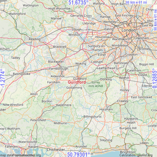
Guildford GPS coordinates[2]
51° 14' 7.296" North, 0° 34' 27.372" West
| Map corner | latitude | longitude |
|---|---|---|
| Upper-left | 51.6735°, | -1.2774° |
| Center: | 51.23536°, | -0.57427° |
| Lower-right: | 50.79301°, | 0.12885° |
| Map W x H: | 97.9×97.9 km | = 60.8×60.8mi |
| max Lat: | 60.39635° ⇑85.9% North |
| Guildford: | 51.23536° |
| min Lat: | ⇓14.1% South 34.60088° |
| min Long | Guildford | max Long |
| -7.64133° | -0.57427° | 32.95536° |
| W 75%⇐ | ⇒25% E |
Elevation
Elevation of Guildford is 46 m = 151 ft, and this is 26.9 m = 88 ft below average elevation for this country.
| Max E: |
515 m = 1690 ft | 60.2% |
| Avg. | 72.9 m = 239 ft | |
| Guildford | 46 m = 151 ft | |
Min E: |
-30 m = -98 ft | 39.8% |
See also: Guildford elevation on elevation.city.
Geographical zone
Guildford is located in North temperate zone (between Tropic of Cancer and the Arctic Circle). Distance of this North polar circle is 1704.3 km =1059 mi to North.| Distance of | km | miles | from Guildford |
|---|---|---|---|
| North Pole | 4310.2 | 2678.2 | to North |
| Arctic Circle | 1704.3 | 1059 | to North |
| Tropic Cancer | 3090.9 | 1920.6 | to South |
| Equator | 5696.8 | 3539.8 | to South |


Nearby cities:
15 places around Guildford: (largest is in red/bold)
• Albury
5.3 km =3.3 mi,  108°
108°
• Bramley
4.7 km =2.9 mi,  167°
167°
• Chilworth
3.7 km =2.3 mi,  125°
125°
• Fairlands
4.4 km =2.7 mi,  311°
311°
• Godalming
6.2 km =3.9 mi,  207°
207°
• Milford
8.8 km =5.5 mi,  217°
217°
• Normandy
7.4 km =4.6 mi,  289°
289°
• Pirbright
8 km =5 mi,  320°
320°
• Puttenham
6.8 km =4.2 mi,  257°
257°
• Send
6.8 km =4.2 mi,  29°
29°
• Shalford
2.6 km =1.6 mi, 173°
• Shere
7.7 km =4.8 mi,  102°
102°
• West Clandon
5.7 km =3.5 mi,  60°
60°
• West Horsley
8.7 km =5.4 mi,  71°
71°
• Wood Street Village
4.7 km =2.9 mi, 291°
Sources, notices
• [Note1] Compared only with cities in United Kingdom existing in our database
• [Src1] Map data: © OpenStreetMap contributors (CC-BY-SA)
• [Src2] Other city data from geonames.org with taken over terms of usage.
• [Src3] Geographical zone / Annual Mean Temperature by Robert A. Rohde @ Wikipedia
