Grimsby geodata
Grimsby (England) is a seat of a second-order administrative division; located in United Kingdom in Europe/London (GMT+1) time zone. With population of 134,160 people, there are 71 cities with bigger population in this country. Compared to other cities in United Kingdom, 71.1% of cities are located further ↓South; 85.4% of cities are located further ←West and 99% of cities have higher elevation than Grimsby. Note1


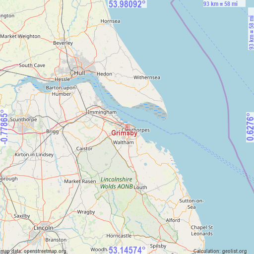
Grimsby GPS coordinates[2]
53° 33' 55.404" North, 0° 4' 31.908" West
| Map corner | latitude | longitude |
|---|---|---|
| Upper-left | 53.98092°, | -0.77865° |
| Center: | 53.56539°, | -0.07553° |
| Lower-right: | 53.14574°, | 0.6276° |
| Map W x H: | 92.9×92.9 km | = 57.7×57.7mi |
| max Lat: | 60.39635° ⇑28.9% North |
| Grimsby: | 53.56539° |
| min Lat: | ⇓71.1% South 34.60088° |
| min Long | Grimsby | max Long |
| -7.64133° | -0.07553° | 32.95536° |
| W 85.4%⇐ | ⇒14.6% E |
Elevation
Elevation of Grimsby is 4 m = 13 ft, and this is 68.9 m = 226 ft below average elevation for this country.
| Max E: |
515 m = 1690 ft | 99% |
| Avg. | 72.9 m = 239 ft | |
| Grimsby | 4 m = 13 ft | |
Min E: |
-30 m = -98 ft | 1% |
See also: Grimsby elevation on elevation.city.
Geographical zone
Grimsby is located in North temperate zone (between Tropic of Cancer and the Arctic Circle). Distance of this North polar circle is 1445.3 km =898.1 mi to North.| Distance of | km | miles | from Grimsby |
|---|---|---|---|
| North Pole | 4051.1 | 2517.2 | to North |
| Arctic Circle | 1445.3 | 898.1 | to North |
| Tropic Cancer | 3350 | 2081.6 | to South |
| Equator | 5955.9 | 3700.8 | to South |


Nearby cities:
15 places around Grimsby: (largest is in red/bold)
• Bradley
4.2 km =2.6 mi,  245°
245°
• Cleethorpes
2.9 km =1.8 mi,  100°
100°
• Great Coates
4.2 km =2.6 mi,  278°
278°
• Grimbsy
1.7 km =1.1 mi, 248°
• Healing
6 km =3.7 mi,  286°
286°
• Holton le Clay
6.7 km =4.2 mi,  172°
172°
• Humberston
5.1 km =3.2 mi,  139°
139°
• Immingham
11 km =6.8 mi,  298°
298°
• Keelby
11.4 km =7.1 mi, 275°
• Laceby
6.7 km =4.2 mi, 246°
• North Thoresby
11.1 km =6.9 mi, 173°
• Stallingborough
7.6 km =4.7 mi, 288°
• Sunk Island
9.6 km =6 mi,  356°
356°
• Tetney
8.9 km =5.5 mi,  156°
156°
• Waltham
5.7 km =3.5 mi,  196°
196°
Sources, notices
• [Note1] Compared only with cities in United Kingdom existing in our database
• [Src1] Map data: © OpenStreetMap contributors (CC-BY-SA)
• [Src2] Other city data from geonames.org with taken over terms of usage.
• [Src3] Geographical zone / Annual Mean Temperature by Robert A. Rohde @ Wikipedia
