Greenock geodata
Greenock (Scotland) is a seat of a second-order administrative division; located in United Kingdom in Europe/London (GMT+1) time zone. With population of 43,690 people, there are 272 cities with bigger population in this country. Compared to other cities in United Kingdom, 93.2% of cities are located further ↓South; 95% of cities are located further →East and 89.9% of cities have higher elevation than Greenock. Note1


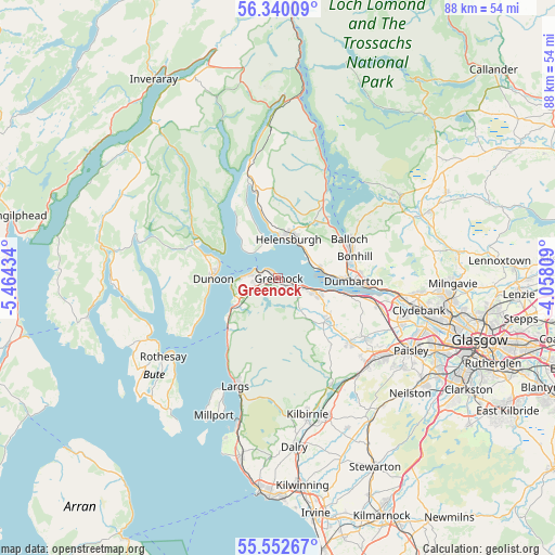
Greenock GPS coordinates[2]
55° 56' 54.168" North, 4° 45' 40.356" West
| Map corner | latitude | longitude |
|---|---|---|
| Upper-left | 56.34009°, | -5.46434° |
| Center: | 55.94838°, | -4.76121° |
| Lower-right: | 55.55267°, | -4.05809° |
| Map W x H: | 87.6×87.6 km | = 54.4×54.4mi |
| max Lat: | 60.39635° ⇑6.8% North |
| Greenock: | 55.94838° |
| min Lat: | ⇓93.2% South 34.60088° |
| min Long | Greenock | max Long |
| -7.64133° | -4.76121° | 32.95536° |
| W 5%⇐ | ⇒95% E |
Elevation
Elevation of Greenock is 12 m = 39 ft, and this is 60.9 m = 200 ft below average elevation for this country.
| Max E: |
515 m = 1690 ft | 89.9% |
| Avg. | 72.9 m = 239 ft | |
| Greenock | 12 m = 39 ft | |
Min E: |
-30 m = -98 ft | 10.1% |
See also: Greenock elevation on elevation.city.
Geographical zone
Greenock is located in North temperate zone (between Tropic of Cancer and the Arctic Circle). Distance of this North polar circle is 1180.3 km =733.4 mi to North.| Distance of | km | miles | from Greenock |
|---|---|---|---|
| North Pole | 3786.2 | 2352.6 | to North |
| Arctic Circle | 1180.3 | 733.4 | to North |
| Tropic Cancer | 3615 | 2246.3 | to South |
| Equator | 6220.9 | 3865.5 | to South |


Nearby cities:
15 places around Greenock: (largest is in red/bold)
• Cardross
6.9 km =4.3 mi,  77°
77°
• Dunoon
10.3 km =6.4 mi,  271°
271°
• Gourock
3.8 km =2.4 mi,  292°
292°
• Helensburgh
6.8 km =4.2 mi,  18°
18°
• Inverkip
8.1 km =5 mi,  236°
236°
• Kilcreggan
5.5 km =3.4 mi,  317°
317°
• Kilmacolm
10.3 km =6.4 mi,  125°
125°
• Langbank
10.9 km =6.8 mi,  104°
104°
• Port Glasgow
4.7 km =2.9 mi,  108°
108°
• Renton
11.3 km =7 mi, 76°
• Rhu
7.6 km =4.7 mi,  357°
357°
• Rosneath
7.3 km =4.5 mi,  339°
339°
• Strone
9.9 km =6.2 mi, 294°
• Vale of Leven
11.6 km =7.2 mi, 77°
• Wemyss Bay
11.3 km =7 mi,  224°
224°
Sources, notices
• [Note1] Compared only with cities in United Kingdom existing in our database
• [Src1] Map data: © OpenStreetMap contributors (CC-BY-SA)
• [Src2] Other city data from geonames.org with taken over terms of usage.
• [Src3] Geographical zone / Annual Mean Temperature by Robert A. Rohde @ Wikipedia
