Great Habton geodata
Great Habton (England) is a seat of a fourth-order administrative division; located in United Kingdom in Europe/London (GMT+1) time zone. In our database, there are 4977 cities with bigger population. Compared to other cities in United Kingdom, 80% of cities are located further ↓South; 69.5% of cities are located further ←West and 76.3% of cities have higher elevation than Great Habton. Note1
Administrative division(s):
- Level 1: England
- Level 2: North Yorkshire
- Level 3: Ryedale District
- Level 4: Habton


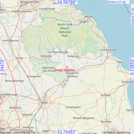
Great Habton GPS coordinates[2]
54° 10' 42.276" North, 0° 50' 29.976" West
| Map corner | latitude | longitude |
|---|---|---|
| Upper-left | 54.58788°, | -1.54478° |
| Center: | 54.17841°, | -0.84166° |
| Lower-right: | 53.76485°, | -0.13853° |
| Map W x H: | 91.5×91.5 km | = 56.9×56.9mi |
| max Lat: | 60.39635° ⇑20% North |
| Great Habton: | 54.17841° |
| min Lat: | ⇓80% South 34.60088° |
| min Long | Great Habton | max Long |
| -7.64133° | -0.84166° | 32.95536° |
| W 69.5%⇐ | ⇒30.5% E |
Elevation
Elevation of Great Habton is 25 m = 82 ft, and this is 47.9 m = 157 ft below average elevation for this country.
| Max E: |
515 m = 1690 ft | 76.3% |
| Avg. | 72.9 m = 239 ft | |
| Great Habton | 25 m = 82 ft | |
Min E: |
-30 m = -98 ft | 23.7% |
See also: United Kingdom elevation on elevation.city.
Geographical zone
Great Habton is located in North temperate zone (between Tropic of Cancer and the Arctic Circle). Distance of this North polar circle is 1377.1 km =855.7 mi to North.| Distance of | km | miles | from Great Habton |
|---|---|---|---|
| North Pole | 3983 | 2474.9 | to North |
| Arctic Circle | 1377.1 | 855.7 | to North |
| Tropic Cancer | 3418.2 | 2124 | to South |
| Equator | 6024.1 | 3743.2 | to South |


Nearby cities:
15 places around Great Habton: (largest is in red/bold)
• Birdsall
11.9 km =7.4 mi,  150°
150°
• Burythorpe
12.4 km =7.7 mi,  165°
165°
• Huttons Ambo
8.4 km =5.2 mi,  182°
182°
• Kirkbymoorside
11.8 km =7.3 mi,  330°
330°
• Langton
9.7 km =6 mi,  157°
157°
• Malton
5.4 km =3.4 mi, 149°
• Marishes
6.6 km =4.1 mi,  65°
65°
• Nawton
13 km =8.1 mi,  311°
311°
• Norton
6.3 km =3.9 mi,  143°
143°
• Pickering
9.3 km =5.8 mi,  31°
31°
• Rillington
9.8 km =6.1 mi,  103°
103°
• Slingsby
6.2 km =3.9 mi,  255°
255°
• Thornton Dale
10.1 km =6.3 mi,  51°
51°
• Thorpe Bassett
10.7 km =6.6 mi,  108°
108°
• Wintringham
13.1 km =8.1 mi, 105°
Sources, notices
• [Note1] Compared only with cities in United Kingdom existing in our database
• [Src1] Map data: © OpenStreetMap contributors (CC-BY-SA)
• [Src2] Other city data from geonames.org with taken over terms of usage.
• [Src3] Geographical zone / Annual Mean Temperature by Robert A. Rohde @ Wikipedia
