Goodwick geodata
Goodwick (Wales) is a populated place; located in United Kingdom in Europe/London (GMT+1) time zone. With population of 1,720 people, there are 2850 cities with bigger population in this country. Compared to other cities in United Kingdom, 61.9% of cities are located further ↑North; 96.3% of cities are located further →East and 76.3% of cities have higher elevation than Goodwick. Note1


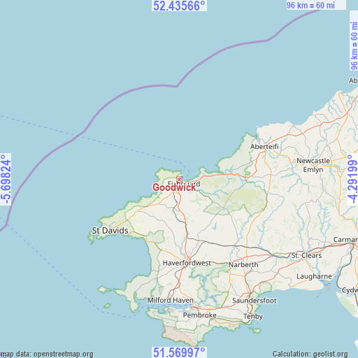
Goodwick GPS coordinates[2]
52° 0' 17.676" North, 4° 59' 42.396" West
| Map corner | latitude | longitude |
|---|---|---|
| Upper-left | 52.43566°, | -5.69824° |
| Center: | 52.00491°, | -4.99511° |
| Lower-right: | 51.56997°, | -4.29199° |
| Map W x H: | 96.3×96.3 km | = 59.8×59.8mi |
| max Lat: | 60.39635° ⇑61.9% North |
| Goodwick: | 52.00491° |
| min Lat: | ⇓38.1% South 34.60088° |
| min Long | Goodwick | max Long |
| -7.64133° | -4.99511° | 32.95536° |
| W 3.7%⇐ | ⇒96.3% E |
Elevation
Elevation of Goodwick is 25 m = 82 ft, and this is 47.9 m = 157 ft below average elevation for this country.
| Max E: |
515 m = 1690 ft | 76.3% |
| Avg. | 72.9 m = 239 ft | |
| Goodwick | 25 m = 82 ft | |
Min E: |
-30 m = -98 ft | 23.7% |
See also: United Kingdom elevation on elevation.city.
Geographical zone
Goodwick is located in North temperate zone (between Tropic of Cancer and the Arctic Circle). Distance of this North polar circle is 1618.8 km =1005.9 mi to North.| Distance of | km | miles | from Goodwick |
|---|---|---|---|
| North Pole | 4224.7 | 2625.1 | to North |
| Arctic Circle | 1618.8 | 1005.9 | to North |
| Tropic Cancer | 3176.5 | 1973.8 | to South |
| Equator | 5782.4 | 3593 | to South |


Nearby cities:
15 places around Goodwick: (largest is in red/bold)
• Ambleston
13.5 km =8.4 mi,  153°
153°
• Brawdy
16.6 km =10.3 mi,  213°
213°
• Camrose
18.2 km =11.3 mi,  183°
183°
• Crundale
20.4 km =12.7 mi,  170°
170°
• Fishguard
1.8 km =1.1 mi,  133°
133°
• Letterston
8.6 km =5.3 mi, 178°
• Llanrhian
14.4 km =8.9 mi,  238°
238°
• Maenclochog
17.6 km =10.9 mi, 126°
• Mathry
9 km =5.6 mi,  223°
223°
• Nevern
13.5 km =8.4 mi,  80°
80°
• Newport
11.1 km =6.9 mi, 83°
• Scleddau
4.1 km =2.5 mi, 178°
• Solva
20.1 km =12.5 mi, 223°
• Spittal
15.5 km =9.6 mi, 166°
• Wiston
21.7 km =13.5 mi,  156°
156°
Sources, notices
• [Note1] Compared only with cities in United Kingdom existing in our database
• [Src1] Map data: © OpenStreetMap contributors (CC-BY-SA)
• [Src2] Other city data from geonames.org with taken over terms of usage.
• [Src3] Geographical zone / Annual Mean Temperature by Robert A. Rohde @ Wikipedia
