Glasgow geodata
Glasgow (Scotland) is a seat of a second-order administrative division; located in United Kingdom in Europe/London (GMT+1) time zone. With population of 591,620 people, there are 6 cities with bigger population in this country. Compared to other cities in United Kingdom, 91.8% of cities are located further ↓South; 91.1% of cities are located further →East and 64.9% of cities have higher elevation than Glasgow. Note1


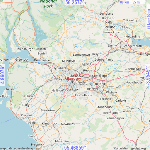
Glasgow GPS coordinates[2]
55° 51' 54.54" North, 4° 15' 27.468" West
| Map corner | latitude | longitude |
|---|---|---|
| Upper-left | 56.2577°, | -4.96076° |
| Center: | 55.86515°, | -4.25763° |
| Lower-right: | 55.46859°, | -3.55451° |
| Map W x H: | 87.7×87.7 km | = 54.5×54.5mi |
| max Lat: | 60.39635° ⇑8.2% North |
| Glasgow: | 55.86515° |
| min Lat: | ⇓91.8% South 34.60088° |
| min Long | Glasgow | max Long |
| -7.64133° | -4.25763° | 32.95536° |
| W 8.9%⇐ | ⇒91.1% E |
Elevation
Elevation of Glasgow is 40 m = 131 ft, and this is 32.9 m = 108 ft below average elevation for this country.
| Max E: |
515 m = 1690 ft | 64.9% |
| Avg. | 72.9 m = 239 ft | |
| Glasgow | 40 m = 131 ft | |
Min E: |
-30 m = -98 ft | 35.1% |
See also: Glasgow elevation on elevation.city.
Geographical zone
Glasgow is located in North temperate zone (between Tropic of Cancer and the Arctic Circle). Distance of this North polar circle is 1189.6 km =739.2 mi to North.| Distance of | km | miles | from Glasgow |
|---|---|---|---|
| North Pole | 3795.4 | 2358.4 | to North |
| Arctic Circle | 1189.6 | 739.2 | to North |
| Tropic Cancer | 3605.7 | 2240.5 | to South |
| Equator | 6211.6 | 3859.7 | to South |


Nearby cities:
15 places around Glasgow: (largest is in red/bold)
• Auchinloch
8.4 km =5.2 mi,  53°
53°
• Bearsden
7.3 km =4.5 mi,  319°
319°
• Bishopbriggs
5.2 km =3.2 mi,  27°
27°
• Cambuslang
8.6 km =5.3 mi,  135°
135°
• Carmunnock
8.4 km =5.2 mi,  170°
170°
• Clarkston
8.9 km =5.5 mi,  187°
187°
• Giffnock
7.2 km =4.5 mi,  198°
198°
• Hawkhead
8.6 km =5.3 mi,  245°
245°
• Milngavie
9.3 km =5.8 mi,  334°
334°
• Netherlee
7.1 km =4.4 mi, 187°
• Renfrew
8.5 km =5.3 mi,  275°
275°
• Rutherglen
4.9 km =3 mi,  145°
145°
• Stepps
7.1 km =4.4 mi,  68°
68°
• Thornliebank
7.7 km =4.8 mi,  209°
209°
• Torrance
8.8 km =5.5 mi,  19°
19°
Sources, notices
• [Note1] Compared only with cities in United Kingdom existing in our database
• [Src1] Map data: © OpenStreetMap contributors (CC-BY-SA)
• [Src2] Other city data from geonames.org with taken over terms of usage.
• [Src3] Geographical zone / Annual Mean Temperature by Robert A. Rohde @ Wikipedia
