Gedney Hill geodata
Gedney Hill (England) is a populated place; located in United Kingdom in Europe/London (GMT+1) time zone. With population of 1,072 people, there are 3536 cities with bigger population in this country. Compared to other cities in United Kingdom, 54.8% of cities are located further ↓South; 86.2% of cities are located further ←West and 98.4% of cities have higher elevation than Gedney Hill. Note1
Administrative division(s):
- Level 1: England
- Level 2: Lincolnshire
- Level 3: South Holland District
- Level 4: Gedney Hill


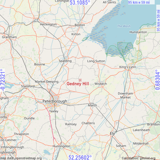
Gedney Hill GPS coordinates[2]
52° 41' 3.624" North, 0° 1' 12.288" West
| Map corner | latitude | longitude |
|---|---|---|
| Upper-left | 53.1085°, | -0.72321° |
| Center: | 52.68434°, | -0.02008° |
| Lower-right: | 52.25602°, | 0.68304° |
| Map W x H: | 94.8×94.8 km | = 58.9×58.9mi |
| max Lat: | 60.39635° ⇑45.2% North |
| Gedney Hill: | 52.68434° |
| min Lat: | ⇓54.8% South 34.60088° |
| min Long | Gedney Hill | max Long |
| -7.64133° | -0.02008° | 32.95536° |
| W 86.2%⇐ | ⇒13.8% E |
Elevation
Elevation of Gedney Hill is 5 m = 16 ft, and this is 67.9 m = 223 ft below average elevation for this country.
| Max E: |
515 m = 1690 ft | 98.4% |
| Avg. | 72.9 m = 239 ft | |
| Gedney Hill | 5 m = 16 ft | |
Min E: |
-30 m = -98 ft | 1.6% |
See also: United Kingdom elevation on elevation.city.
Geographical zone
Gedney Hill is located in North temperate zone (between Tropic of Cancer and the Arctic Circle). Distance of this North polar circle is 1543.2 km =958.9 mi to North.| Distance of | km | miles | from Gedney Hill |
|---|---|---|---|
| North Pole | 4149.1 | 2578.1 | to North |
| Arctic Circle | 1543.2 | 958.9 | to North |
| Tropic Cancer | 3252 | 2020.7 | to South |
| Equator | 5857.9 | 3639.9 | to South |


Nearby cities:
15 places around Gedney Hill: (largest is in red/bold)
• Cowbit
10 km =6.2 mi,  312°
312°
• Crowland
10.1 km =6.3 mi,  264°
264°
• Eye
14.4 km =8.9 mi,  233°
233°
• Fleet
13.2 km =8.2 mi,  23°
23°
• Holbeach
13.5 km =8.4 mi,  9°
9°
• Holbeach Clough
15.6 km =9.7 mi,  2°
2°
• Moulton Chapel
8.1 km =5 mi,  328°
328°
• Murrow
5.6 km =3.5 mi,  145°
145°
• Newborough
14.6 km =9.1 mi,  249°
249°
• Parson Drove
4.3 km =2.7 mi,  136°
136°
• Spalding
14.4 km =8.9 mi,  322°
322°
• Thorney
9.2 km =5.7 mi,  220°
220°
• West Walton
13.2 km =8.2 mi,  83°
83°
• Whaplode
12.8 km =8 mi,  355°
355°
• Wisbech
12.3 km =7.6 mi,  99°
99°
Sources, notices
• [Note1] Compared only with cities in United Kingdom existing in our database
• [Src1] Map data: © OpenStreetMap contributors (CC-BY-SA)
• [Src2] Other city data from geonames.org with taken over terms of usage.
• [Src3] Geographical zone / Annual Mean Temperature by Robert A. Rohde @ Wikipedia
