Galashiels geodata
Galashiels (Scotland) is a populated place; located in United Kingdom in Europe/London (GMT+0) time zone. With population of 12,660 people, there are 894 cities with bigger population in this country. Compared to other cities in United Kingdom, 89.4% of cities are located further ↓South; 71.1% of cities are located further →East and 80.6% of cities have lower elevation than Galashiels. Note1


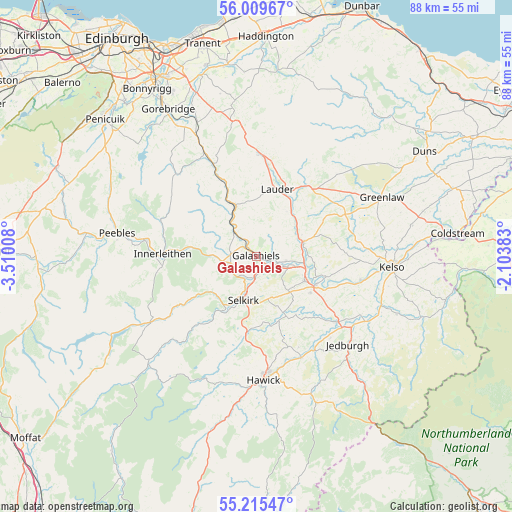
Galashiels GPS coordinates[2]
55° 36' 52.488" North, 2° 48' 25.02" West
| Map corner | latitude | longitude |
|---|---|---|
| Upper-left | 56.00967°, | -3.51008° |
| Center: | 55.61458°, | -2.80695° |
| Lower-right: | 55.21547°, | -2.10383° |
| Map W x H: | 88.3×88.3 km | = 54.9×54.9mi |
| max Lat: | 60.39635° ⇑10.6% North |
| Galashiels: | 55.61458° |
| min Lat: | ⇓89.4% South 34.60088° |
| min Long | Galashiels | max Long |
| -7.64133° | -2.80695° | 32.95536° |
| W 28.9%⇐ | ⇒71.1% E |
Elevation
Elevation of Galashiels is 119 m = 390 ft, and this is 46.1 m = 151 ft above average elevation for this country.
| Max E: |
515 m = 1690 ft | 19.4% |
| Galashiels | 119 m 390 ft | |
| Avg. | 72.9 m = 239 ft | |
Min E: |
-30 m = -98 ft | 80.6% |
See also: United Kingdom elevation on elevation.city.
Geographical zone
Galashiels is located in North temperate zone (between Tropic of Cancer and the Arctic Circle). Distance of this North polar circle is 1217.4 km =756.5 mi to North.| Distance of | km | miles | from Galashiels |
|---|---|---|---|
| North Pole | 3823.3 | 2375.7 | to North |
| Arctic Circle | 1217.4 | 756.5 | to North |
| Tropic Cancer | 3577.8 | 2223.1 | to South |
| Equator | 6183.8 | 3842.4 | to South |


Nearby cities:
15 places around Galashiels: (largest is in red/bold)
• Cardrona Mains
18.9 km =11.7 mi,  277°
277°
• Denholm
19.1 km =11.9 mi,  156°
156°
• Earlston
8.7 km =5.4 mi,  72°
72°
• Hawick
21.4 km =13.3 mi,  176°
176°
• Innerleithen
16.1 km =10 mi,  271°
271°
• Jedburgh
21.9 km =13.6 mi,  133°
133°
• Kelso
23.5 km =14.6 mi,  94°
94°
• Lauder
12.2 km =7.6 mi,  17°
17°
• Melrose
5.2 km =3.2 mi,  108°
108°
• Newtown St Boswells
9.5 km =5.9 mi, 114°
• Saint Boswells
11.2 km =7 mi, 114°
• Selkirk
7.7 km =4.8 mi,  195°
195°
• Stow
9.5 km =5.9 mi,  337°
337°
• Tweedbank
2.8 km =1.7 mi, 114°
• Walkerburn
13.1 km =8.1 mi, 274°
Sources, notices
• [Note1] Compared only with cities in United Kingdom existing in our database
• [Src1] Map data: © OpenStreetMap contributors (CC-BY-SA)
• [Src2] Other city data from geonames.org with taken over terms of usage.
• [Src3] Geographical zone / Annual Mean Temperature by Robert A. Rohde @ Wikipedia
