Flamborough geodata
Flamborough (England) is a seat of a third-order administrative division; located in United Kingdom in Europe/London (GMT+1) time zone. With population of 1,914 people, there are 2692 cities with bigger population in this country. Compared to other cities in United Kingdom, 79.5% of cities are located further ↓South; 84.4% of cities are located further ←West and 60.2% of cities have higher elevation than Flamborough. Note1


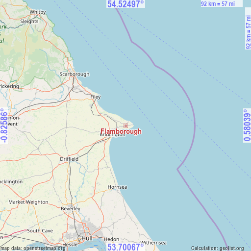
Flamborough GPS coordinates[2]
54° 6' 53.532" North, 0° 7' 21.864" West
| Map corner | latitude | longitude |
|---|---|---|
| Upper-left | 54.52497°, | -0.82586° |
| Center: | 54.11487°, | -0.12274° |
| Lower-right: | 53.70067°, | 0.58039° |
| Map W x H: | 91.7×91.7 km | = 57×57mi |
| max Lat: | 60.39635° ⇑20.5% North |
| Flamborough: | 54.11487° |
| min Lat: | ⇓79.5% South 34.60088° |
| min Long | Flamborough | max Long |
| -7.64133° | -0.12274° | 32.95536° |
| W 84.4%⇐ | ⇒15.6% E |
Elevation
Elevation of Flamborough is 46 m = 151 ft, and this is 26.9 m = 88 ft below average elevation for this country.
| Max E: |
515 m = 1690 ft | 60.2% |
| Avg. | 72.9 m = 239 ft | |
| Flamborough | 46 m = 151 ft | |
Min E: |
-30 m = -98 ft | 39.8% |
See also: United Kingdom elevation on elevation.city.
Geographical zone
Flamborough is located in North temperate zone (between Tropic of Cancer and the Arctic Circle). Distance of this North polar circle is 1384.2 km =860.1 mi to North.| Distance of | km | miles | from Flamborough |
|---|---|---|---|
| North Pole | 3990.1 | 2479.3 | to North |
| Arctic Circle | 1384.2 | 860.1 | to North |
| Tropic Cancer | 3411.1 | 2119.6 | to South |
| Equator | 6017 | 3738.8 | to South |


Nearby cities:
15 places around Flamborough: (largest is in red/bold)
• Atwick
19.9 km =12.4 mi,  192°
192°
• Barmston
13.2 km =8.2 mi,  211°
211°
• Beeford
19.4 km =12.1 mi, 213°
• Bempton
4 km =2.5 mi,  295°
295°
• Boynton
9.5 km =5.9 mi,  258°
258°
• Bridlington
5.7 km =3.5 mi,  231°
231°
• Carnaby
10.8 km =6.7 mi,  235°
235°
• Filey
15.1 km =9.4 mi,  314°
314°
• Grindale
9.9 km =6.2 mi,  276°
276°
• Hunmanby
14.7 km =9.1 mi, 299°
• Kilham
17.7 km =11 mi,  251°
251°
• Skipsea
16.6 km =10.3 mi,  202°
202°
• Thwing
17.4 km =10.8 mi,  270°
270°
• Ulrome
15.3 km =9.5 mi, 207°
• Wold Newton
18.3 km =11.4 mi, 279°
Sources, notices
• [Note1] Compared only with cities in United Kingdom existing in our database
• [Src1] Map data: © OpenStreetMap contributors (CC-BY-SA)
• [Src2] Other city data from geonames.org with taken over terms of usage.
• [Src3] Geographical zone / Annual Mean Temperature by Robert A. Rohde @ Wikipedia
