Exeter geodata
Exeter (England) is a seat of a second-order administrative division; located in United Kingdom in Europe/London (GMT+1) time zone. With population of 117,763 people, there are 79 cities with bigger population in this country. Compared to other cities in United Kingdom, 96.3% of cities are located further ↑North; 82.7% of cities are located further →East and 60.2% of cities have higher elevation than Exeter. Note1


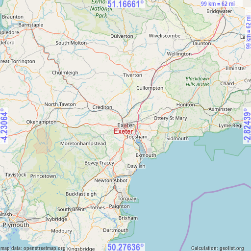
Exeter GPS coordinates[2]
50° 43' 24.96" North, 3° 31' 39.036" West
| Map corner | latitude | longitude |
|---|---|---|
| Upper-left | 51.16661°, | -4.23064° |
| Center: | 50.7236°, | -3.52751° |
| Lower-right: | 50.27636°, | -2.82439° |
| Map W x H: | 99×99 km | = 61.5×61.5mi |
| max Lat: | 60.39635° ⇑96.3% North |
| Exeter: | 50.7236° |
| min Lat: | ⇓3.7% South 34.60088° |
| min Long | Exeter | max Long |
| -7.64133° | -3.52751° | 32.95536° |
| W 17.3%⇐ | ⇒82.7% E |
Elevation
Elevation of Exeter is 46 m = 151 ft, and this is 26.9 m = 88 ft below average elevation for this country.
| Max E: |
515 m = 1690 ft | 60.2% |
| Avg. | 72.9 m = 239 ft | |
| Exeter | 46 m = 151 ft | |
Min E: |
-30 m = -98 ft | 39.8% |
See also: Exeter elevation on elevation.city.
Geographical zone
Exeter is located in North temperate zone (between Tropic of Cancer and the Arctic Circle). Distance of this North polar circle is 1761.2 km =1094.4 mi to North.| Distance of | km | miles | from Exeter |
|---|---|---|---|
| North Pole | 4367.1 | 2713.6 | to North |
| Arctic Circle | 1761.2 | 1094.4 | to North |
| Tropic Cancer | 3034 | 1885.2 | to South |
| Equator | 5639.9 | 3504.5 | to South |


Nearby cities:
15 places around Exeter: (largest is in red/bold)
• Aylesbeare
11.6 km =7.2 mi,  92°
92°
• Christow
11.5 km =7.1 mi,  227°
227°
• Clyst St Mary
5.7 km =3.5 mi,  108°
108°
• Crediton
10.9 km =6.8 mi,  307°
307°
• Exminster
5.2 km =3.2 mi,  155°
155°
• Heavitree
2.2 km =1.4 mi,  99°
99°
• Kennford
6.3 km =3.9 mi,  185°
185°
• Kenton
10.1 km =6.3 mi, 157°
• Lympstone
10.8 km =6.7 mi,  141°
141°
• Newton St Cyres
6.8 km =4.2 mi,  319°
319°
• Silverton
10.8 km =6.7 mi,  16°
16°
• Stoke Canon
5.5 km =3.4 mi,  14°
14°
• Thorverton
9.4 km =5.8 mi,  359°
359°
• Topsham
6 km =3.7 mi,  134°
134°
• Woodbury
10.3 km =6.4 mi,  120°
120°
Sources, notices
• [Note1] Compared only with cities in United Kingdom existing in our database
• [Src1] Map data: © OpenStreetMap contributors (CC-BY-SA)
• [Src2] Other city data from geonames.org with taken over terms of usage.
• [Src3] Geographical zone / Annual Mean Temperature by Robert A. Rohde @ Wikipedia
