Edinburgh geodata
Edinburgh (Scotland) is a seat of a first-order administrative division; located in United Kingdom in Europe/London (GMT+1) time zone. With population of 464,990 people, there are 8 cities with bigger population in this country. Compared to other cities in United Kingdom, 93.2% of cities are located further ↓South; 78.3% of cities are located further →East and 53.5% of cities have lower elevation than Edinburgh. Note1


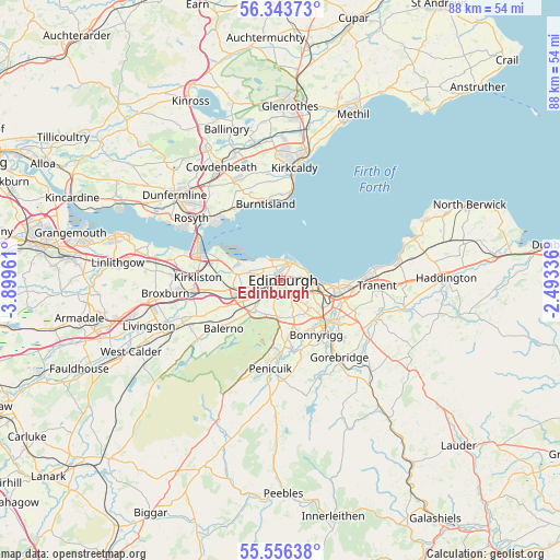
Edinburgh GPS coordinates[2]
55° 57' 7.416" North, 3° 11' 47.328" West
| Map corner | latitude | longitude |
|---|---|---|
| Upper-left | 56.34373°, | -3.89961° |
| Center: | 55.95206°, | -3.19648° |
| Lower-right: | 55.55638°, | -2.49336° |
| Map W x H: | 87.5×87.5 km | = 54.4×54.4mi |
| max Lat: | 60.39635° ⇑6.8% North |
| Edinburgh: | 55.95206° |
| min Lat: | ⇓93.2% South 34.60088° |
| min Long | Edinburgh | max Long |
| -7.64133° | -3.19648° | 32.95536° |
| W 21.7%⇐ | ⇒78.3% E |
Elevation
Elevation of Edinburgh is 66 m = 217 ft, and this is 6.9 m = 23 ft below average elevation for this country.
| Max E: |
515 m = 1690 ft | 46.5% |
| Avg. | 72.9 m = 239 ft | |
| Edinburgh | 66 m = 217 ft | |
Min E: |
-30 m = -98 ft | 53.5% |
See also: Edinburgh elevation on elevation.city.
Geographical zone
Edinburgh is located in North temperate zone (between Tropic of Cancer and the Arctic Circle). Distance of this North polar circle is 1179.9 km =733.2 mi to North.| Distance of | km | miles | from Edinburgh |
|---|---|---|---|
| North Pole | 3785.8 | 2352.4 | to North |
| Arctic Circle | 1179.9 | 733.2 | to North |
| Tropic Cancer | 3615.4 | 2246.5 | to South |
| Equator | 6221.3 | 3865.7 | to South |


Nearby cities:
15 places around Edinburgh: (largest is in red/bold)
• Balerno
11.7 km =7.3 mi,  229°
229°
• Bilston
9.2 km =5.7 mi,  172°
172°
• Bonnyrigg
10.4 km =6.5 mi,  146°
146°
• Burntisland
12.5 km =7.8 mi,  349°
349°
• Colinton
6.2 km =3.9 mi,  216°
216°
• Currie
9.3 km =5.8 mi, 228°
• Dalkeith
10.3 km =6.4 mi,  129°
129°
• Danderhall
6.8 km =4.2 mi, 128°
• Loanhead
8.4 km =5.2 mi,  163°
163°
• Musselburgh
9.2 km =5.7 mi,  97°
97°
• Ratho
11.9 km =7.4 mi,  253°
253°
• Ratho Station
12.1 km =7.5 mi,  261°
261°
• Rosewell
11.9 km =7.4 mi, 161°
• Roslin
10.7 km =6.6 mi, 170°
• Whitecraig
10.3 km =6.4 mi,  110°
110°
In other languages:
- In Spanish: Edimburgo
- In France: Édimbourg
- In Italian: Edimburgo
- In Russian: Эдинбург
- In Chinese: 爱丁堡
Sources, notices
• [Note1] Compared only with cities in United Kingdom existing in our database
• [Src1] Map data: © OpenStreetMap contributors (CC-BY-SA)
• [Src2] Other city data from geonames.org with taken over terms of usage.
• [Src3] Geographical zone / Annual Mean Temperature by Robert A. Rohde @ Wikipedia
