East Hanney geodata
East Hanney (England) is a populated place; located in United Kingdom in Europe/London (GMT+1) time zone. With population of 1,238 people, there are 3313 cities with bigger population in this country. Compared to other cities in United Kingdom, 73.2% of cities are located further ↑North; 57.8% of cities are located further ←West and 51.8% of cities have lower elevation than East Hanney. Note1
Administrative division(s):
- Level 1: England
- Level 2: Oxfordshire
- Level 3: Vale of White Horse District
- Level 4: East Hanney


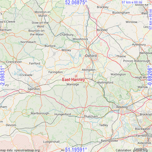
East Hanney GPS coordinates[2]
51° 38' 3.948" North, 1° 23' 42.648" West
| Map corner | latitude | longitude |
|---|---|---|
| Upper-left | 52.06875°, | -2.09831° |
| Center: | 51.63443°, | -1.39518° |
| Lower-right: | 51.19591°, | -0.69206° |
| Map W x H: | 97.1×97 km | = 60.3×60.3mi |
| max Lat: | 60.39635° ⇑73.2% North |
| East Hanney: | 51.63443° |
| min Lat: | ⇓26.8% South 34.60088° |
| min Long | East Hanney | max Long |
| -7.64133° | -1.39518° | 32.95536° |
| W 57.8%⇐ | ⇒42.2% E |
Elevation
Elevation of East Hanney is 63 m = 207 ft, and this is 9.9 m = 32 ft below average elevation for this country.
| Max E: |
515 m = 1690 ft | 48.2% |
| Avg. | 72.9 m = 239 ft | |
| East Hanney | 63 m = 207 ft | |
Min E: |
-30 m = -98 ft | 51.8% |
See also: United Kingdom elevation on elevation.city.
Geographical zone
East Hanney is located in North temperate zone (between Tropic of Cancer and the Arctic Circle). Distance of this North polar circle is 1660 km =1031.5 mi to North.| Distance of | km | miles | from East Hanney |
|---|---|---|---|
| North Pole | 4265.9 | 2650.7 | to North |
| Arctic Circle | 1660 | 1031.5 | to North |
| Tropic Cancer | 3135.3 | 1948.2 | to South |
| Equator | 5741.2 | 3567.4 | to South |


Nearby cities:
15 places around East Hanney: (largest is in red/bold)
• Abingdon
8.8 km =5.5 mi,  62°
62°
• Appleton
8.7 km =5.4 mi,  15°
15°
• Childrey
8.1 km =5 mi,  226°
226°
• East Challow
6.4 km =4 mi,  217°
217°
• Frilford
4.6 km =2.9 mi,  28°
28°
• Grove
3.3 km =2.1 mi,  213°
213°
• Harwell
8.1 km =5 mi,  118°
118°
• Kingston Bagpuize
5.5 km =3.4 mi,  341°
341°
• Letcombe Regis
7.5 km =4.7 mi, 211°
• Longworth
7 km =4.3 mi, 335°
• Marcham
5.2 km =3.2 mi,  44°
44°
• Stanford in the Vale
7.7 km =4.8 mi,  274°
274°
• Steventon
5.2 km =3.2 mi,  101°
101°
• Sutton Courtenay
8.2 km =5.1 mi,  84°
84°
• Wantage
5.5 km =3.4 mi,  202°
202°
Sources, notices
• [Note1] Compared only with cities in United Kingdom existing in our database
• [Src1] Map data: © OpenStreetMap contributors (CC-BY-SA)
• [Src2] Other city data from geonames.org with taken over terms of usage.
• [Src3] Geographical zone / Annual Mean Temperature by Robert A. Rohde @ Wikipedia
