Durham geodata
Durham (England) is a seat of a second-order administrative division; located in United Kingdom in Europe/London (GMT+1) time zone. With population of 47,785 people, there are 247 cities with bigger population in this country. Compared to other cities in United Kingdom, 84.8% of cities are located further ↓South; 53.8% of cities are located further ←West and 55.9% of cities have higher elevation than Durham. Note1


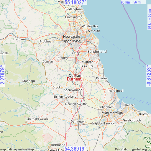
Durham GPS coordinates[2]
54° 46' 36.336" North, 1° 34' 32.376" West
| Map corner | latitude | longitude |
|---|---|---|
| Upper-left | 55.18027°, | -2.27879° |
| Center: | 54.77676°, | -1.57566° |
| Lower-right: | 54.36919°, | -0.87253° |
| Map W x H: | 90.2×90.2 km | = 56×56mi |
| max Lat: | 60.39635° ⇑15.2% North |
| Durham: | 54.77676° |
| min Lat: | ⇓84.8% South 34.60088° |
| min Long | Durham | max Long |
| -7.64133° | -1.57566° | 32.95536° |
| W 53.8%⇐ | ⇒46.2% E |
Elevation
Elevation of Durham is 52 m = 171 ft, and this is 20.9 m = 69 ft below average elevation for this country.
| Max E: |
515 m = 1690 ft | 55.9% |
| Avg. | 72.9 m = 239 ft | |
| Durham | 52 m = 171 ft | |
Min E: |
-30 m = -98 ft | 44.1% |
See also: Durham elevation on elevation.city.
Geographical zone
Durham is located in North temperate zone (between Tropic of Cancer and the Arctic Circle). Distance of this North polar circle is 1310.6 km =814.4 mi to North.| Distance of | km | miles | from Durham |
|---|---|---|---|
| North Pole | 3916.5 | 2433.6 | to North |
| Arctic Circle | 1310.6 | 814.4 | to North |
| Tropic Cancer | 3484.7 | 2165.3 | to South |
| Equator | 6090.6 | 3784.5 | to South |


Nearby cities:
15 places around Durham: (largest is in red/bold)
• Bowburn
5.3 km =3.3 mi,  142°
142°
• Brandon
4 km =2.5 mi,  221°
221°
• Coxhoe
8.3 km =5.2 mi,  146°
146°
• Croxdale
5.4 km =3.4 mi,  186°
186°
• East Rainton
8.1 km =5 mi,  48°
48°
• Langley Park
6.6 km =4.1 mi,  292°
292°
• Pittington
6.5 km =4 mi,  66°
66°
• Sacriston
5.5 km =3.4 mi,  325°
325°
• Sherburn
4.5 km =2.8 mi,  90°
90°
• Sherburn Hill
6.2 km =3.9 mi, 94°
• Spennymoor
8.8 km =5.5 mi, 191°
• Ushaw Moor
4.6 km =2.9 mi,  271°
271°
• West Cornforth
9 km =5.6 mi,  156°
156°
• West Rainton
6.6 km =4.1 mi, 47°
• Witton Gilbert
5.1 km =3.2 mi,  309°
309°
Sources, notices
• [Note1] Compared only with cities in United Kingdom existing in our database
• [Src1] Map data: © OpenStreetMap contributors (CC-BY-SA)
• [Src2] Other city data from geonames.org with taken over terms of usage.
• [Src3] Geographical zone / Annual Mean Temperature by Robert A. Rohde @ Wikipedia
