Dunfermline geodata
Dunfermline (Scotland) is a populated place; located in United Kingdom in Europe/London (GMT+1) time zone. With population of 50,380 people, there are 231 cities with bigger population in this country. Compared to other cities in United Kingdom, 94.8% of cities are located further ↓South; 81.7% of cities are located further →East and 75.2% of cities have lower elevation than Dunfermline. Note1


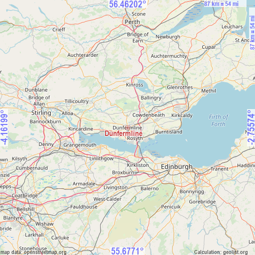
Dunfermline GPS coordinates[2]
56° 4' 17.616" North, 3° 27' 31.932" West
| Map corner | latitude | longitude |
|---|---|---|
| Upper-left | 56.46202°, | -4.16199° |
| Center: | 56.07156°, | -3.45887° |
| Lower-right: | 55.6771°, | -2.75574° |
| Map W x H: | 87.3×87.3 km | = 54.2×54.2mi |
| max Lat: | 60.39635° ⇑5.2% North |
| Dunfermline: | 56.07156° |
| min Lat: | ⇓94.8% South 34.60088° |
| min Long | Dunfermline | max Long |
| -7.64133° | -3.45887° | 32.95536° |
| W 18.3%⇐ | ⇒81.7% E |
Elevation
Elevation of Dunfermline is 107 m = 351 ft, and this is 34.1 m = 112 ft above average elevation for this country.
| Max E: |
515 m = 1690 ft | 24.8% |
| Dunfermline | 107 m 351 ft | |
| Avg. | 72.9 m = 239 ft | |
Min E: |
-30 m = -98 ft | 75.2% |
See also: Dunfermline elevation on elevation.city.
Geographical zone
Dunfermline is located in North temperate zone (between Tropic of Cancer and the Arctic Circle). Distance of this North polar circle is 1166.6 km =724.9 mi to North.| Distance of | km | miles | from Dunfermline |
|---|---|---|---|
| North Pole | 3772.5 | 2344.1 | to North |
| Arctic Circle | 1166.6 | 724.9 | to North |
| Tropic Cancer | 3628.7 | 2254.8 | to South |
| Equator | 6234.6 | 3874 | to South |


Nearby cities:
15 places around Dunfermline: (largest is in red/bold)
• Cairneyhill
4.9 km =3 mi,  253°
253°
• Carnock
5.2 km =3.2 mi,  285°
285°
• Comrie
7.5 km =4.7 mi,  281°
281°
• Cowdenbeath
8.4 km =5.2 mi,  57°
57°
• Crossford
2.5 km =1.6 mi, 248°
• Crossgates
5.2 km =3.2 mi,  75°
75°
• Dalgety Bay
7.9 km =4.9 mi,  121°
121°
• Inverkeithing
5.8 km =3.6 mi,  137°
137°
• Kelty
8.2 km =5.1 mi,  32°
32°
• Kingseat
4.4 km =2.7 mi,  48°
48°
• Limekilns
4.4 km =2.7 mi,  194°
194°
• North Queensferry
8.1 km =5 mi,  148°
148°
• Oakley
6.6 km =4.1 mi, 282°
• Rosyth
4.1 km =2.5 mi,  161°
161°
• Townhill
2.3 km =1.4 mi, 32°
Sources, notices
• [Note1] Compared only with cities in United Kingdom existing in our database
• [Src1] Map data: © OpenStreetMap contributors (CC-BY-SA)
• [Src2] Other city data from geonames.org with taken over terms of usage.
• [Src3] Geographical zone / Annual Mean Temperature by Robert A. Rohde @ Wikipedia
