Doncaster geodata
Doncaster (England) is a seat of a second-order administrative division; located in United Kingdom in Europe/London (GMT+1) time zone. With population of 158,141 people, there are 56 cities with bigger population in this country. Compared to other cities in United Kingdom, 70.3% of cities are located further ↓South; 64.2% of cities are located further ←West and 82% of cities have higher elevation than Doncaster. Note1


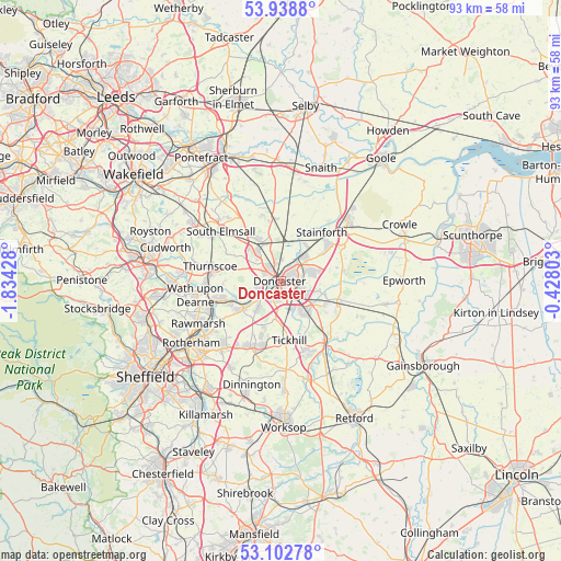
Doncaster GPS coordinates[2]
53° 31' 22.26" North, 1° 7' 52.176" West
| Map corner | latitude | longitude |
|---|---|---|
| Upper-left | 53.9388°, | -1.83428° |
| Center: | 53.52285°, | -1.13116° |
| Lower-right: | 53.10278°, | -0.42803° |
| Map W x H: | 93×93 km | = 57.8×57.8mi |
| max Lat: | 60.39635° ⇑29.7% North |
| Doncaster: | 53.52285° |
| min Lat: | ⇓70.3% South 34.60088° |
| min Long | Doncaster | max Long |
| -7.64133° | -1.13116° | 32.95536° |
| W 64.2%⇐ | ⇒35.8% E |
Elevation
Elevation of Doncaster is 19 m = 62 ft, and this is 53.9 m = 177 ft below average elevation for this country.
| Max E: |
515 m = 1690 ft | 82% |
| Avg. | 72.9 m = 239 ft | |
| Doncaster | 19 m = 62 ft | |
Min E: |
-30 m = -98 ft | 18% |
See also: Doncaster elevation on elevation.city.
Geographical zone
Doncaster is located in North temperate zone (between Tropic of Cancer and the Arctic Circle). Distance of this North polar circle is 1450 km =901 mi to North.| Distance of | km | miles | from Doncaster |
|---|---|---|---|
| North Pole | 4055.9 | 2520.2 | to North |
| Arctic Circle | 1450 | 901 | to North |
| Tropic Cancer | 3345.3 | 2078.7 | to South |
| Equator | 5951.2 | 3697.9 | to South |


Nearby cities:
15 places around Doncaster: (largest is in red/bold)
• Adwick le Street
6.4 km =4 mi,  326°
326°
• Armthorpe
5.3 km =3.3 mi,  75°
75°
• Auckley
7.5 km =4.7 mi,  106°
106°
• Barnburgh
9.4 km =5.8 mi,  270°
270°
• Bentley
1.7 km =1.1 mi,  313°
313°
• Braithwell
9.7 km =6 mi,  208°
208°
• Cantley
5.9 km =3.7 mi,  115°
115°
• Carcroft
7.3 km =4.5 mi,  335°
335°
• Conisbrough
8.1 km =5 mi,  235°
235°
• Finningley
10.1 km =6.3 mi, 113°
• Kirk Sandall
6 km =3.7 mi,  43°
43°
• Marr
6.3 km =3.9 mi,  290°
290°
• Rossington
6.7 km =4.2 mi,  136°
136°
• Tickhill
10.2 km =6.3 mi,  171°
171°
• Wadworth
6.2 km =3.9 mi,  186°
186°
Sources, notices
• [Note1] Compared only with cities in United Kingdom existing in our database
• [Src1] Map data: © OpenStreetMap contributors (CC-BY-SA)
• [Src2] Other city data from geonames.org with taken over terms of usage.
• [Src3] Geographical zone / Annual Mean Temperature by Robert A. Rohde @ Wikipedia
