Cumbernauld geodata
Cumbernauld (Scotland) is a populated place; located in United Kingdom in Europe/London (GMT+0) time zone. With population of 51,610 people, there are 224 cities with bigger population in this country. Compared to other cities in United Kingdom, 93.2% of cities are located further ↓South; 87.9% of cities are located further →East and 89.6% of cities have lower elevation than Cumbernauld. Note1


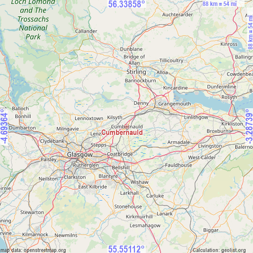
Cumbernauld GPS coordinates[2]
55° 56' 48.66" North, 3° 59' 25.836" West
| Map corner | latitude | longitude |
|---|---|---|
| Upper-left | 56.33858°, | -4.69364° |
| Center: | 55.94685°, | -3.99051° |
| Lower-right: | 55.55112°, | -3.28739° |
| Map W x H: | 87.6×87.6 km | = 54.4×54.4mi |
| max Lat: | 60.39635° ⇑6.8% North |
| Cumbernauld: | 55.94685° |
| min Lat: | ⇓93.2% South 34.60088° |
| min Long | Cumbernauld | max Long |
| -7.64133° | -3.99051° | 32.95536° |
| W 12.1%⇐ | ⇒87.9% E |
Elevation
Elevation of Cumbernauld is 149 m = 489 ft, and this is 76.1 m = 250 ft above average elevation for this country.
| Max E: |
515 m = 1690 ft | 10.4% |
| Cumbernauld | 149 m 489 ft | |
| Avg. | 72.9 m = 239 ft | |
Min E: |
-30 m = -98 ft | 89.6% |
See also: Cumbernauld elevation on elevation.city.
Geographical zone
Cumbernauld is located in North temperate zone (between Tropic of Cancer and the Arctic Circle). Distance of this North polar circle is 1180.5 km =733.5 mi to North.| Distance of | km | miles | from Cumbernauld |
|---|---|---|---|
| North Pole | 3786.4 | 2352.8 | to North |
| Arctic Circle | 1180.5 | 733.5 | to North |
| Tropic Cancer | 3614.8 | 2246.1 | to South |
| Equator | 6220.7 | 3865.4 | to South |


Nearby cities:
15 places around Cumbernauld: (largest is in red/bold)
• Banknock
5.2 km =3.2 mi,  24°
24°
• Croy
3.4 km =2.1 mi,  296°
296°
• Dennyloanhead
7.5 km =4.7 mi,  39°
39°
• Dullatur
2.7 km =1.7 mi,  331°
331°
• Gartcosh
8.6 km =5.3 mi,  221°
221°
• Glenboig
6.8 km =4.2 mi,  210°
210°
• Glenmavis
6.4 km =4 mi,  178°
178°
• Greenhill
8 km =5 mi,  50°
50°
• Haggs
5.8 km =3.6 mi,  34°
34°
• Head of Muir
8.2 km =5.1 mi, 35°
• Kilsyth
5.4 km =3.4 mi,  307°
307°
• Moodiesburn
6.8 km =4.2 mi,  238°
238°
• Plains
8.5 km =5.3 mi,  150°
150°
• Queenzieburn
6.9 km =4.3 mi,  294°
294°
• Twechar
5.8 km =3.6 mi,  278°
278°
Sources, notices
• [Note1] Compared only with cities in United Kingdom existing in our database
• [Src1] Map data: © OpenStreetMap contributors (CC-BY-SA)
• [Src2] Other city data from geonames.org with taken over terms of usage.
• [Src3] Geographical zone / Annual Mean Temperature by Robert A. Rohde @ Wikipedia
