Crewe geodata
Crewe (England) is a populated place; located in United Kingdom in Europe/London (GMT+1) time zone. With population of 75,556 people, there are 137 cities with bigger population in this country. Compared to other cities in United Kingdom, 62% of cities are located further ↓South; 63.9% of cities are located further →East and 50.4% of cities have higher elevation than Crewe. Note1


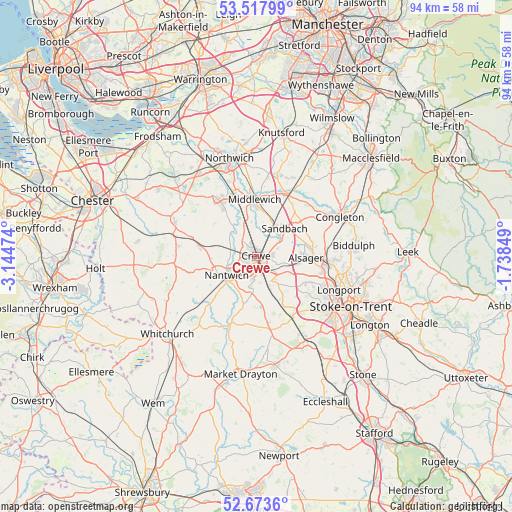
Crewe GPS coordinates[2]
53° 5' 52.332" North, 2° 26' 29.796" West
| Map corner | latitude | longitude |
|---|---|---|
| Upper-left | 53.51799°, | -3.14474° |
| Center: | 53.09787°, | -2.44161° |
| Lower-right: | 52.6736°, | -1.73849° |
| Map W x H: | 93.9×93.9 km | = 58.3×58.3mi |
| max Lat: | 60.39635° ⇑38% North |
| Crewe: | 53.09787° |
| min Lat: | ⇓62% South 34.60088° |
| min Long | Crewe | max Long |
| -7.64133° | -2.44161° | 32.95536° |
| W 36.1%⇐ | ⇒63.9% E |
Elevation
Elevation of Crewe is 60 m = 197 ft, and this is 12.9 m = 42 ft below average elevation for this country.
| Max E: |
515 m = 1690 ft | 50.4% |
| Avg. | 72.9 m = 239 ft | |
| Crewe | 60 m = 197 ft | |
Min E: |
-30 m = -98 ft | 49.6% |
See also: Crewe elevation on elevation.city.
Geographical zone
Crewe is located in North temperate zone (between Tropic of Cancer and the Arctic Circle). Distance of this North polar circle is 1497.2 km =930.3 mi to North.| Distance of | km | miles | from Crewe |
|---|---|---|---|
| North Pole | 4103.1 | 2549.5 | to North |
| Arctic Circle | 1497.2 | 930.3 | to North |
| Tropic Cancer | 3298 | 2049.3 | to South |
| Equator | 5903.9 | 3668.5 | to South |


Nearby cities:
15 places around Crewe: (largest is in red/bold)
• Alsager
9 km =5.6 mi,  91°
91°
• Audlem
12.8 km =8 mi,  199°
199°
• Audley
10.9 km =6.8 mi,  119°
119°
• Betley
8.6 km =5.3 mi,  145°
145°
• Chorlton
5.8 km =3.6 mi,  155°
155°
• Holmes Chapel
12.8 km =8 mi,  25°
25°
• Middlewich
10.6 km =6.6 mi,  359°
359°
• Nantwich
6.2 km =3.9 mi,  238°
238°
• Over
11.9 km =7.4 mi,  322°
322°
• Rode Heath
10.2 km =6.3 mi,  79°
79°
• Sandbach
7.4 km =4.6 mi,  45°
45°
• Weston
4.4 km =2.7 mi,  141°
141°
• Willaston
4.4 km =2.7 mi,  218°
218°
• Winsford
11.8 km =7.3 mi,  332°
332°
• Wybunbury
5.9 km =3.7 mi,  186°
186°
Sources, notices
• [Note1] Compared only with cities in United Kingdom existing in our database
• [Src1] Map data: © OpenStreetMap contributors (CC-BY-SA)
• [Src2] Other city data from geonames.org with taken over terms of usage.
• [Src3] Geographical zone / Annual Mean Temperature by Robert A. Rohde @ Wikipedia
