Crawley geodata
Crawley (England) is a populated place; located in United Kingdom in Europe/London (GMT+1) time zone. With population of 180,508 people, there are 44 cities with bigger population in this country. Compared to other cities in United Kingdom, 88.9% of cities are located further ↑North; 83.3% of cities are located further ←West and 64% of cities have lower elevation than Crawley. Note1


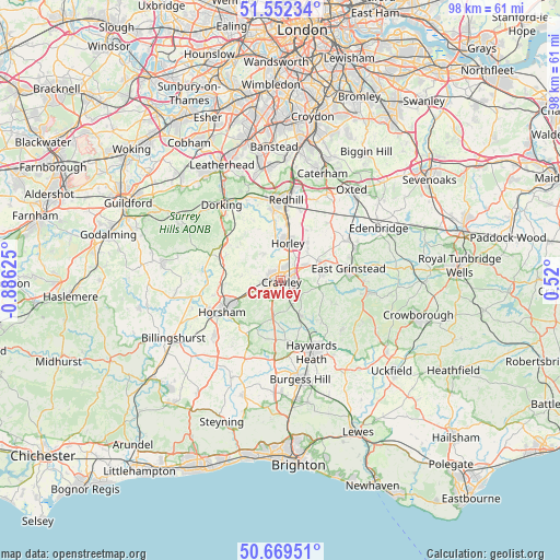
Crawley GPS coordinates[2]
51° 6' 46.908" North, 0° 10' 59.232" West
| Map corner | latitude | longitude |
|---|---|---|
| Upper-left | 51.55234°, | -0.88625° |
| Center: | 51.11303°, | -0.18312° |
| Lower-right: | 50.66951°, | 0.52° |
| Map W x H: | 98.2×98.2 km | = 61×61mi |
| max Lat: | 60.39635° ⇑88.9% North |
| Crawley: | 51.11303° |
| min Lat: | ⇓11.1% South 34.60088° |
| min Long | Crawley | max Long |
| -7.64133° | -0.18312° | 32.95536° |
| W 83.3%⇐ | ⇒16.7% E |
Elevation
Elevation of Crawley is 84 m = 276 ft, and this is 11.1 m = 36 ft above average elevation for this country.
| Max E: |
515 m = 1690 ft | 36% |
| Crawley | 84 m 276 ft | |
| Avg. | 72.9 m = 239 ft | |
Min E: |
-30 m = -98 ft | 64% |
See also: Crawley elevation on elevation.city.
Geographical zone
Crawley is located in North temperate zone (between Tropic of Cancer and the Arctic Circle). Distance of this North polar circle is 1717.9 km =1067.5 mi to North.| Distance of | km | miles | from Crawley |
|---|---|---|---|
| North Pole | 4323.8 | 2686.7 | to North |
| Arctic Circle | 1717.9 | 1067.5 | to North |
| Tropic Cancer | 3077.3 | 1912.1 | to South |
| Equator | 5683.2 | 3531.4 | to South |


Nearby cities:
15 places around Crawley: (largest is in red/bold)
• Balcombe
7.1 km =4.4 mi,  151°
151°
• Bewbush
3 km =1.9 mi,  248°
248°
• Broadfield
2.4 km =1.5 mi,  222°
222°
• Charlwood
5.7 km =3.5 mi,  328°
328°
• Copthorne
5.4 km =3.4 mi,  57°
57°
• Crawley Down
7.4 km =4.6 mi,  83°
83°
• Furnace Green
1.2 km =0.7 mi,  122°
122°
• Gossops Green
2.4 km =1.5 mi,  264°
264°
• Handcross
6.7 km =4.2 mi,  190°
190°
• Horley
7 km =4.3 mi,  13°
13°
• Langley Green
2 km =1.2 mi, 327°
• Maidenbower
2.2 km =1.4 mi,  105°
105°
• Newdigate
9.6 km =6 mi,  308°
308°
• Rusper
6.7 km =4.2 mi,  278°
278°
• Turners Hill
6.9 km =4.3 mi,  98°
98°
Sources, notices
• [Note1] Compared only with cities in United Kingdom existing in our database
• [Src1] Map data: © OpenStreetMap contributors (CC-BY-SA)
• [Src2] Other city data from geonames.org with taken over terms of usage.
• [Src3] Geographical zone / Annual Mean Temperature by Robert A. Rohde @ Wikipedia
