Colchester geodata
Colchester (England) is a populated place; located in United Kingdom in Europe/London (GMT+1) time zone. With population of 121,859 people, there are 77 cities with bigger population in this country. Compared to other cities in United Kingdom, 65.2% of cities are located further ↑North; 95.7% of cities are located further ←West and 73.1% of cities have higher elevation than Colchester. Note1


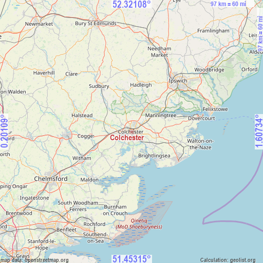
Colchester GPS coordinates[2]
51° 53' 21.156" North, 0° 54' 15.156" East
| Map corner | latitude | longitude |
|---|---|---|
| Upper-left | 52.32108°, | 0.20109° |
| Center: | 51.88921°, | 0.90421° |
| Lower-right: | 51.45315°, | 1.60734° |
| Map W x H: | 96.5×96.5 km | = 60×60mi |
| max Lat: | 60.39635° ⇑65.2% North |
| Colchester: | 51.88921° |
| min Lat: | ⇓34.8% South 34.60088° |
| min Long | Colchester | max Long |
| -7.64133° | 0.90421° | 32.95536° |
| W 95.7%⇐ | ⇒4.3% E |
Elevation
Elevation of Colchester is 29 m = 95 ft, and this is 43.9 m = 144 ft below average elevation for this country.
| Max E: |
515 m = 1690 ft | 73.1% |
| Avg. | 72.9 m = 239 ft | |
| Colchester | 29 m = 95 ft | |
Min E: |
-30 m = -98 ft | 26.9% |
See also: Colchester elevation on elevation.city.
Geographical zone
Colchester is located in North temperate zone (between Tropic of Cancer and the Arctic Circle). Distance of this North polar circle is 1631.6 km =1013.8 mi to North.| Distance of | km | miles | from Colchester |
|---|---|---|---|
| North Pole | 4237.5 | 2633.1 | to North |
| Arctic Circle | 1631.6 | 1013.8 | to North |
| Tropic Cancer | 3163.6 | 1965.8 | to South |
| Equator | 5769.5 | 3585 | to South |


Nearby cities:
15 places around Colchester: (largest is in red/bold)
• Abberton
6.1 km =3.8 mi,  175°
175°
• Alresford
7.8 km =4.8 mi,  120°
120°
• Ardleigh
6.9 km =4.3 mi,  53°
53°
• Boxted
6.6 km =4.1 mi,  3°
3°
• Dedham
9.9 km =6.2 mi,  38°
38°
• Eight Ash Green
5.6 km =3.5 mi,  277°
277°
• Elmstead Market
6.3 km =3.9 mi,  97°
97°
• Great Horkesley
5.8 km =3.6 mi,  340°
340°
• Layer de la Haye
5.8 km =3.6 mi,  213°
213°
• Marks Tey
9.7 km =6 mi,  261°
261°
• Nayland
9.5 km =5.9 mi,  346°
346°
• Peldon
8.6 km =5.3 mi,  188°
188°
• Rowhedge
4.5 km =2.8 mi,  141°
141°
• West Bergholt
4.5 km =2.8 mi,  304°
304°
• Wivenhoe
5.3 km =3.3 mi, 135°
Sources, notices
• [Note1] Compared only with cities in United Kingdom existing in our database
• [Src1] Map data: © OpenStreetMap contributors (CC-BY-SA)
• [Src2] Other city data from geonames.org with taken over terms of usage.
• [Src3] Geographical zone / Annual Mean Temperature by Robert A. Rohde @ Wikipedia
