Cockfield geodata
Cockfield (England) is a populated place; located in United Kingdom in Europe/London (GMT+1) time zone. With population of 1,531 people, there are 3014 cities with bigger population in this country. Compared to other cities in United Kingdom, 83.3% of cities are located further ↓South; 51.2% of cities are located further →East and 98% of cities have lower elevation than Cockfield. Note1


Cockfield GPS coordinates[2]
54° 36' 49.428" North, 1° 48' 32.292" West
| Map corner | latitude | longitude |
|---|---|---|
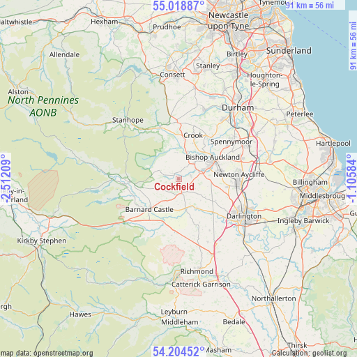
| Upper-left | 55.01887°, | -2.51209° |
| Center: | 54.61373°, | -1.80897° |
| Lower-right: | 54.20452°, | -1.10584° |
| Map W x H: | 90.5×90.5 km | = 56.2×56.2mi |
| max Lat: | 60.39635° ⇑16.7% North |
| Cockfield: | 54.61373° |
| min Lat: | ⇓83.3% South 34.60088° |
| min Long | Cockfield | max Long |
| -7.64133° | -1.80897° | 32.95536° |
| W 48.8%⇐ | ⇒51.2% E |
Elevation
Elevation of Cockfield is 224 m = 735 ft, and this is 151.1 m = 496 ft above average elevation for this country.
| Max E: |
515 m = 1690 ft | 2% |
| Cockfield | 224 m 735 ft | |
| Avg. | 72.9 m = 239 ft | |
Min E: |
-30 m = -98 ft | 98% |
See also: United Kingdom elevation on elevation.city.
Geographical zone
Cockfield is located in North temperate zone (between Tropic of Cancer and the Arctic Circle). Distance of this North polar circle is 1328.7 km =825.6 mi to North.| Distance of | km | miles | from Cockfield |
|---|---|---|---|
| North Pole | 3934.6 | 2444.8 | to North |
| Arctic Circle | 1328.7 | 825.6 | to North |
| Tropic Cancer | 3466.6 | 2154 | to South |
| Equator | 6072.5 | 3773.3 | to South |


Nearby cities:
15 places around Cockfield: (largest is in red/bold)
• Barnard Castle
10.7 km =6.6 mi,  221°
221°
• Bishop Auckland
9.7 km =6 mi,  61°
61°
• Denton
10.6 km =6.6 mi,  119°
119°
• Evenwood
3.2 km =2 mi,  73°
73°
• Gainford
8.8 km =5.5 mi,  147°
147°
• Hamsterley
7.8 km =4.8 mi,  356°
356°
• High Etherley
6.1 km =3.8 mi,  43°
43°
• Hunwick
10.6 km =6.6 mi, 38°
• Ingleton
6.1 km =3.8 mi,  128°
128°
• Low Etherley
6.1 km =3.8 mi, 43°
• Ovington
9.6 km =6 mi,  175°
175°
• Staindrop
3.6 km =2.2 mi, 178°
• Summerhouse
9.3 km =5.8 mi, 123°
• Winston
7.7 km =4.8 mi,  170°
170°
• Witton le Wear
7.2 km =4.5 mi,  18°
18°
Sources, notices
• [Note1] Compared only with cities in United Kingdom existing in our database
• [Src1] Map data: © OpenStreetMap contributors (CC-BY-SA)
• [Src2] Other city data from geonames.org with taken over terms of usage.
• [Src3] Geographical zone / Annual Mean Temperature by Robert A. Rohde @ Wikipedia
