Coatbridge geodata
Coatbridge (Scotland) is a populated place; located in United Kingdom in Europe/London (GMT+0) time zone. With population of 43,970 people, there are 267 cities with bigger population in this country. Compared to other cities in United Kingdom, 91.7% of cities are located further ↓South; 88.1% of cities are located further →East and 66% of cities have lower elevation than Coatbridge. Note1


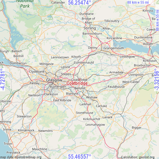
Coatbridge GPS coordinates[2]
55° 51' 43.776" North, 4° 1' 28.884" West
| Map corner | latitude | longitude |
|---|---|---|
| Upper-left | 56.25474°, | -4.72781° |
| Center: | 55.86216°, | -4.02469° |
| Lower-right: | 55.46557°, | -3.32156° |
| Map W x H: | 87.7×87.7 km | = 54.5×54.5mi |
| max Lat: | 60.39635° ⇑8.3% North |
| Coatbridge: | 55.86216° |
| min Lat: | ⇓91.7% South 34.60088° |
| min Long | Coatbridge | max Long |
| -7.64133° | -4.02469° | 32.95536° |
| W 11.9%⇐ | ⇒88.1% E |
Elevation
Elevation of Coatbridge is 88 m = 289 ft, and this is 15.1 m = 50 ft above average elevation for this country.
| Max E: |
515 m = 1690 ft | 34% |
| Coatbridge | 88 m 289 ft | |
| Avg. | 72.9 m = 239 ft | |
Min E: |
-30 m = -98 ft | 66% |
See also: Coatbridge elevation on elevation.city.
Geographical zone
Coatbridge is located in North temperate zone (between Tropic of Cancer and the Arctic Circle). Distance of this North polar circle is 1189.9 km =739.4 mi to North.| Distance of | km | miles | from Coatbridge |
|---|---|---|---|
| North Pole | 3795.8 | 2358.6 | to North |
| Arctic Circle | 1189.9 | 739.4 | to North |
| Tropic Cancer | 3605.4 | 2240.3 | to South |
| Equator | 6211.3 | 3859.5 | to South |


Nearby cities:
15 places around Coatbridge: (largest is in red/bold)
• Airdrie
2.8 km =1.7 mi,  81°
81°
• Bargeddie
3.5 km =2.2 mi,  254°
254°
• Bellshill
5.1 km =3.2 mi,  174°
174°
• Calderbank
4 km =2.5 mi,  122°
122°
• Chapelhall
5.2 km =3.2 mi,  113°
113°
• Chryston
6.9 km =4.3 mi,  311°
311°
• Gartcosh
4.6 km =2.9 mi, 309°
• Glenboig
3.8 km =2.4 mi,  339°
339°
• Glenmavis
3.8 km =2.4 mi,  37°
37°
• Holytown
5.7 km =3.5 mi,  145°
145°
• Muirhead
6.4 km =4 mi, 308°
• New Stevenston
6 km =3.7 mi, 147°
• Plains
6.6 km =4.1 mi,  72°
72°
• Uddingston
6 km =3.7 mi,  217°
217°
• Viewpark
4.4 km =2.7 mi,  207°
207°
Sources, notices
• [Note1] Compared only with cities in United Kingdom existing in our database
• [Src1] Map data: © OpenStreetMap contributors (CC-BY-SA)
• [Src2] Other city data from geonames.org with taken over terms of usage.
• [Src3] Geographical zone / Annual Mean Temperature by Robert A. Rohde @ Wikipedia
