Clutton geodata
Clutton (England) is a seat of a third-order administrative division; located in United Kingdom in Europe/London (GMT+1) time zone. With population of 2,739 people, there are 2223 cities with bigger population in this country. Compared to other cities in United Kingdom, 83.3% of cities are located further ↑North; 65.9% of cities are located further →East and 80.9% of cities have lower elevation than Clutton. Note1


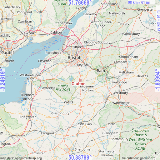
Clutton GPS coordinates[2]
51° 19' 45.984" North, 2° 32' 35.016" West
| Map corner | latitude | longitude |
|---|---|---|
| Upper-left | 51.76668°, | -3.24619° |
| Center: | 51.32944°, | -2.54306° |
| Lower-right: | 50.88799°, | -1.83994° |
| Map W x H: | 97.7×97.7 km | = 60.7×60.7mi |
| max Lat: | 60.39635° ⇑83.3% North |
| Clutton: | 51.32944° |
| min Lat: | ⇓16.7% South 34.60088° |
| min Long | Clutton | max Long |
| -7.64133° | -2.54306° | 32.95536° |
| W 34.1%⇐ | ⇒65.9% E |
Elevation
Elevation of Clutton is 120 m = 394 ft, and this is 47.1 m = 155 ft above average elevation for this country.
| Max E: |
515 m = 1690 ft | 19.1% |
| Clutton | 120 m 394 ft | |
| Avg. | 72.9 m = 239 ft | |
Min E: |
-30 m = -98 ft | 80.9% |
See also: United Kingdom elevation on elevation.city.
Geographical zone
Clutton is located in North temperate zone (between Tropic of Cancer and the Arctic Circle). Distance of this North polar circle is 1693.9 km =1052.5 mi to North.| Distance of | km | miles | from Clutton |
|---|---|---|---|
| North Pole | 4299.8 | 2671.8 | to North |
| Arctic Circle | 1693.9 | 1052.5 | to North |
| Tropic Cancer | 3101.4 | 1927.1 | to South |
| Equator | 5707.3 | 3546.4 | to South |


Nearby cities:
15 places around Clutton: (largest is in red/bold)
• Bishop Sutton
3.6 km =2.2 mi,  278°
278°
• Cameley
1.9 km =1.2 mi,  219°
219°
• Camerton
6.2 km =3.9 mi,  103°
103°
• Chew Magna
6.2 km =3.9 mi,  311°
311°
• Chew Stoke
6.8 km =4.2 mi,  293°
293°
• Compton Dando
5.9 km =3.7 mi,  19°
19°
• East Harptree
6.3 km =3.9 mi,  240°
240°
• Farmborough
4.2 km =2.6 mi,  67°
67°
• Farrington Gurney
3.7 km =2.3 mi,  164°
164°
• Midsomer Norton
6.3 km =3.9 mi,  140°
140°
• Paulton
4 km =2.5 mi,  132°
132°
• Pensford
4.6 km =2.9 mi,  356°
356°
• Publow
5.5 km =3.4 mi, 359°
• Stanton Drew
5.2 km =3.2 mi,  324°
324°
• Timsbury
4.5 km =2.8 mi, 97°
Sources, notices
• [Note1] Compared only with cities in United Kingdom existing in our database
• [Src1] Map data: © OpenStreetMap contributors (CC-BY-SA)
• [Src2] Other city data from geonames.org with taken over terms of usage.
• [Src3] Geographical zone / Annual Mean Temperature by Robert A. Rohde @ Wikipedia
