Clacton-on-Sea geodata
Clacton-on-Sea (England) is a populated place; located in United Kingdom in Europe/London (GMT+1) time zone. With population of 50,548 people, there are 230 cities with bigger population in this country. Compared to other cities in United Kingdom, 68.2% of cities are located further ↑North; 97.4% of cities are located further ←West and 83.6% of cities have higher elevation than Clacton-on-Sea. Note1


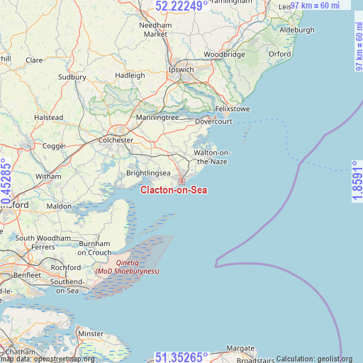
Clacton-on-Sea GPS coordinates[2]
51° 47' 22.812" North, 1° 9' 21.492" East
| Map corner | latitude | longitude |
|---|---|---|
| Upper-left | 52.22249°, | 0.45285° |
| Center: | 51.78967°, | 1.15597° |
| Lower-right: | 51.35265°, | 1.8591° |
| Map W x H: | 96.7×96.7 km | = 60.1×60.1mi |
| max Lat: | 60.39635° ⇑68.2% North |
| Clacton-on-Sea: | 51.78967° |
| min Lat: | ⇓31.8% South 34.60088° |
| min Long | Clacton-on-Sea | max Long |
| -7.64133° | 1.15597° | 32.95536° |
| W 97.4%⇐ | ⇒2.6% E |
Elevation
Elevation of Clacton-on-Sea is 17 m = 56 ft, and this is 55.9 m = 183 ft below average elevation for this country.
| Max E: |
515 m = 1690 ft | 83.6% |
| Avg. | 72.9 m = 239 ft | |
| Clacton-on-Sea | 17 m = 56 ft | |
Min E: |
-30 m = -98 ft | 16.4% |
See also: Clacton-on-Sea elevation on elevation.city.
Geographical zone
Clacton-on-Sea is located in North temperate zone (between Tropic of Cancer and the Arctic Circle). Distance of this North polar circle is 1642.7 km =1020.7 mi to North.| Distance of | km | miles | from Clacton-on-Sea |
|---|---|---|---|
| North Pole | 4248.6 | 2640 | to North |
| Arctic Circle | 1642.7 | 1020.7 | to North |
| Tropic Cancer | 3152.6 | 1958.9 | to South |
| Equator | 5758.5 | 3578.2 | to South |


Nearby cities:
15 places around Clacton-on-Sea: (largest is in red/bold)
• Abberton
17.6 km =10.9 mi,  286°
286°
• Alresford
12.8 km =8 mi,  304°
304°
• Brightlingsea
9.4 km =5.8 mi,  284°
284°
• Elmstead Market
15.1 km =9.4 mi,  312°
312°
• Frinton-on-Sea
7.6 km =4.7 mi,  53°
53°
• Great Bentley
9.5 km =5.9 mi,  318°
318°
• Great Oakley
12.8 km =8 mi,  9°
9°
• Little Clacton
4.1 km =2.5 mi,  346°
346°
• Mistley
17.8 km =11.1 mi,  343°
343°
• Rowhedge
16.3 km =10.1 mi, 297°
• Saint Osyth
5.1 km =3.2 mi, 282°
• Thorpe le Soken
7.4 km =4.6 mi, 5°
• Walton-on-the-Naze
10 km =6.2 mi, 49°
• West Mersea
16.4 km =10.2 mi,  265°
265°
• Wivenhoe
15.5 km =9.6 mi, 298°
Sources, notices
• [Note1] Compared only with cities in United Kingdom existing in our database
• [Src1] Map data: © OpenStreetMap contributors (CC-BY-SA)
• [Src2] Other city data from geonames.org with taken over terms of usage.
• [Src3] Geographical zone / Annual Mean Temperature by Robert A. Rohde @ Wikipedia
