Cirencester geodata
Cirencester (England) is a populated place; located in United Kingdom in Europe/London (GMT+1) time zone. With population of 17,153 people, there are 693 cities with bigger population in this country. Compared to other cities in United Kingdom, 70.3% of cities are located further ↑North; 54.2% of cities are located further →East and 77.7% of cities have lower elevation than Cirencester. Note1
Administrative division(s):
- Level 1: England
- Level 2: Gloucestershire
- Level 3: Cotswold District
- Level 4: Cirencester


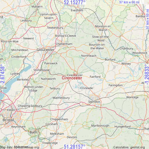
Cirencester GPS coordinates[2]
51° 43' 9.372" North, 1° 58' 17.22" West
| Map corner | latitude | longitude |
|---|---|---|
| Upper-left | 52.15277°, | -2.67458° |
| Center: | 51.71927°, | -1.97145° |
| Lower-right: | 51.28157°, | -1.26833° |
| Map W x H: | 96.9×96.9 km | = 60.2×60.2mi |
| max Lat: | 60.39635° ⇑70.3% North |
| Cirencester: | 51.71927° |
| min Lat: | ⇓29.7% South 34.60088° |
| min Long | Cirencester | max Long |
| -7.64133° | -1.97145° | 32.95536° |
| W 45.8%⇐ | ⇒54.2% E |
Elevation
Elevation of Cirencester is 112 m = 367 ft, and this is 39.1 m = 128 ft above average elevation for this country.
| Max E: |
515 m = 1690 ft | 22.3% |
| Cirencester | 112 m 367 ft | |
| Avg. | 72.9 m = 239 ft | |
Min E: |
-30 m = -98 ft | 77.7% |
See also: United Kingdom elevation on elevation.city.
Geographical zone
Cirencester is located in North temperate zone (between Tropic of Cancer and the Arctic Circle). Distance of this North polar circle is 1650.5 km =1025.6 mi to North.| Distance of | km | miles | from Cirencester |
|---|---|---|---|
| North Pole | 4256.4 | 2644.8 | to North |
| Arctic Circle | 1650.5 | 1025.6 | to North |
| Tropic Cancer | 3144.7 | 1954 | to South |
| Equator | 5750.6 | 3573.3 | to South |


Nearby cities:
15 places around Cirencester: (largest is in red/bold)
• Ampney Crucis
4.6 km =2.9 mi,  97°
97°
• Arlington
10.3 km =6.4 mi,  64°
64°
• Ashton Keynes
8.7 km =5.4 mi,  161°
161°
• Bisley
12.3 km =7.6 mi,  287°
287°
• Chedworth
9.7 km =6 mi,  20°
20°
• Coates
4.5 km =2.8 mi,  253°
253°
• Cricklade
11.8 km =7.3 mi,  138°
138°
• Crudwell
11.7 km =7.3 mi,  215°
215°
• Down Ampney
9.4 km =5.8 mi,  122°
122°
• Kemble
5.9 km =3.7 mi,  213°
213°
• Latton
9.7 km =6 mi,  133°
133°
• Minety
11.5 km =7.1 mi,  172°
172°
• Oaksey
9.2 km =5.7 mi,  199°
199°
• South Cerney
5.8 km =3.6 mi,  151°
151°
• Stratton
1.7 km =1.1 mi,  340°
340°
Sources, notices
• [Note1] Compared only with cities in United Kingdom existing in our database
• [Src1] Map data: © OpenStreetMap contributors (CC-BY-SA)
• [Src2] Other city data from geonames.org with taken over terms of usage.
• [Src3] Geographical zone / Annual Mean Temperature by Robert A. Rohde @ Wikipedia
