Chichester geodata
Chichester (England) is a seat of a second-order administrative division; located in United Kingdom in Europe/London (GMT+1) time zone. With population of 31,654 people, there are 388 cities with bigger population in this country. Compared to other cities in United Kingdom, 94.5% of cities are located further ↑North; 70.7% of cities are located further ←West and 80.8% of cities have higher elevation than Chichester. Note1


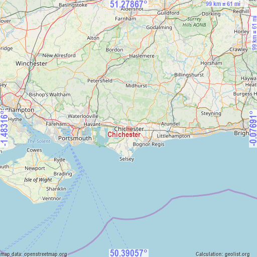
Chichester GPS coordinates[2]
50° 50' 12.228" North, 0° 46' 48.108" West
| Map corner | latitude | longitude |
|---|---|---|
| Upper-left | 51.27867°, | -1.48316° |
| Center: | 50.83673°, | -0.78003° |
| Lower-right: | 50.39057°, | -0.07691° |
| Map W x H: | 98.7×98.7 km | = 61.3×61.3mi |
| max Lat: | 60.39635° ⇑94.5% North |
| Chichester: | 50.83673° |
| min Lat: | ⇓5.5% South 34.60088° |
| min Long | Chichester | max Long |
| -7.64133° | -0.78003° | 32.95536° |
| W 70.7%⇐ | ⇒29.3% E |
Elevation
Elevation of Chichester is 20 m = 66 ft, and this is 52.9 m = 174 ft below average elevation for this country.
| Max E: |
515 m = 1690 ft | 80.8% |
| Avg. | 72.9 m = 239 ft | |
| Chichester | 20 m = 66 ft | |
Min E: |
-30 m = -98 ft | 19.2% |
See also: United Kingdom elevation on elevation.city.
Geographical zone
Chichester is located in North temperate zone (between Tropic of Cancer and the Arctic Circle). Distance of this North polar circle is 1748.7 km =1086.6 mi to North.| Distance of | km | miles | from Chichester |
|---|---|---|---|
| North Pole | 4354.5 | 2705.8 | to North |
| Arctic Circle | 1748.7 | 1086.6 | to North |
| Tropic Cancer | 3046.6 | 1893.1 | to South |
| Equator | 5652.5 | 3512.3 | to South |


Nearby cities:
15 places around Chichester: (largest is in red/bold)
• Barnham
10 km =6.2 mi,  93°
93°
• Birdham
5.8 km =3.6 mi,  218°
218°
• Bognor Regis
9.3 km =5.8 mi,  130°
130°
• Bosham
5.2 km =3.2 mi,  262°
262°
• Boxgrove
5.3 km =3.3 mi,  62°
62°
• East Wittering
10 km =6.2 mi, 221°
• Emsworth
11.1 km =6.9 mi,  276°
276°
• Fontwell
9.5 km =5.9 mi,  77°
77°
• Graffham
14.4 km =8.9 mi,  28°
28°
• Selsey
11.3 km =7 mi,  183°
183°
• Tangmere
4.8 km =3 mi,  70°
70°
• Walberton
11.3 km =7 mi, 85°
• West Wittering
10.2 km =6.3 mi,  232°
232°
• Westergate
7.6 km =4.7 mi, 87°
• Yapton
11.9 km =7.4 mi,  98°
98°
Sources, notices
• [Note1] Compared only with cities in United Kingdom existing in our database
• [Src1] Map data: © OpenStreetMap contributors (CC-BY-SA)
• [Src2] Other city data from geonames.org with taken over terms of usage.
• [Src3] Geographical zone / Annual Mean Temperature by Robert A. Rohde @ Wikipedia
