Chesterfield geodata
Chesterfield (England) is a populated place; located in United Kingdom in Europe/London (GMT+1) time zone. With population of 113,057 people, there are 83 cities with bigger population in this country. Compared to other cities in United Kingdom, 64.8% of cities are located further ↓South; 57.3% of cities are located further ←West and 66.5% of cities have lower elevation than Chesterfield. Note1


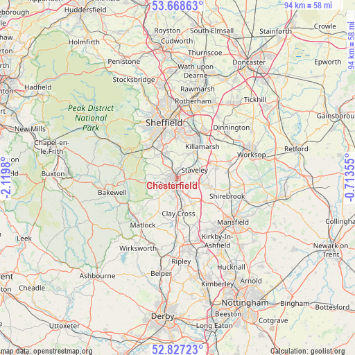
Chesterfield GPS coordinates[2]
53° 15' 0" North, 1° 25' 0.012" West
| Map corner | latitude | longitude |
|---|---|---|
| Upper-left | 53.66863°, | -2.1198° |
| Center: | 53.25°, | -1.41667° |
| Lower-right: | 52.82723°, | -0.71355° |
| Map W x H: | 93.6×93.6 km | = 58.2×58.2mi |
| max Lat: | 60.39635° ⇑35.2% North |
| Chesterfield: | 53.25° |
| min Lat: | ⇓64.8% South 34.60088° |
| min Long | Chesterfield | max Long |
| -7.64133° | -1.41667° | 32.95536° |
| W 57.3%⇐ | ⇒42.7% E |
Elevation
Elevation of Chesterfield is 89 m = 292 ft, and this is 16.1 m = 53 ft above average elevation for this country.
| Max E: |
515 m = 1690 ft | 33.5% |
| Chesterfield | 89 m 292 ft | |
| Avg. | 72.9 m = 239 ft | |
Min E: |
-30 m = -98 ft | 66.5% |
See also: Chesterfield elevation on elevation.city.
Geographical zone
Chesterfield is located in North temperate zone (between Tropic of Cancer and the Arctic Circle). Distance of this North polar circle is 1480.3 km =919.8 mi to North.| Distance of | km | miles | from Chesterfield |
|---|---|---|---|
| North Pole | 4086.2 | 2539 | to North |
| Arctic Circle | 1480.3 | 919.8 | to North |
| Tropic Cancer | 3314.9 | 2059.8 | to South |
| Equator | 5920.8 | 3679 | to South |


Nearby cities:
15 places around Chesterfield: (largest is in red/bold)
• Ashover
10.2 km =6.3 mi,  203°
203°
• Barlborough
9.5 km =5.9 mi,  63°
63°
• Beighton
10.8 km =6.7 mi,  30°
30°
• Bolsover
8.6 km =5.3 mi,  106°
106°
• Clowne
10.5 km =6.5 mi,  74°
74°
• Dronfield
7 km =4.3 mi,  326°
326°
• Glapwell
11.2 km =7 mi,  127°
127°
• Harthill
12.4 km =7.7 mi,  53°
53°
• Holmesfield
8.4 km =5.2 mi,  306°
306°
• Killamarsh
10.6 km =6.6 mi,  38°
38°
• Pilsley
11.6 km =7.2 mi,  163°
163°
• Staveley
4.8 km =3 mi, 67°
• Tibshelf
12.8 km =8 mi, 156°
• Walton
4.2 km =2.6 mi,  224°
224°
• Wingerworth
5.5 km =3.4 mi,  191°
191°
Sources, notices
• [Note1] Compared only with cities in United Kingdom existing in our database
• [Src1] Map data: © OpenStreetMap contributors (CC-BY-SA)
• [Src2] Other city data from geonames.org with taken over terms of usage.
• [Src3] Geographical zone / Annual Mean Temperature by Robert A. Rohde @ Wikipedia
