Chester geodata
Chester (England) is a seat of a second-order administrative division; located in United Kingdom in Europe/London (GMT+0) time zone. With population of 90,524 people, there are 109 cities with bigger population in this country. Compared to other cities in United Kingdom, 63.6% of cities are located further ↓South; 73% of cities are located further →East and 69.2% of cities have higher elevation than Chester. Note1


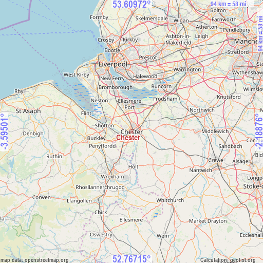
Chester GPS coordinates[2]
53° 11' 25.8" North, 2° 53' 30.804" West
| Map corner | latitude | longitude |
|---|---|---|
| Upper-left | 53.60972°, | -3.59501° |
| Center: | 53.1905°, | -2.89189° |
| Lower-right: | 52.76715°, | -2.18876° |
| Map W x H: | 93.7×93.7 km | = 58.2×58.2mi |
| max Lat: | 60.39635° ⇑36.4% North |
| Chester: | 53.1905° |
| min Lat: | ⇓63.6% South 34.60088° |
| min Long | Chester | max Long |
| -7.64133° | -2.89189° | 32.95536° |
| W 27%⇐ | ⇒73% E |
Elevation
Elevation of Chester is 34 m = 112 ft, and this is 38.9 m = 128 ft below average elevation for this country.
| Max E: |
515 m = 1690 ft | 69.2% |
| Avg. | 72.9 m = 239 ft | |
| Chester | 34 m = 112 ft | |
Min E: |
-30 m = -98 ft | 30.8% |
See also: Chester elevation on elevation.city.
Geographical zone
Chester is located in North temperate zone (between Tropic of Cancer and the Arctic Circle). Distance of this North polar circle is 1486.9 km =923.9 mi to North.| Distance of | km | miles | from Chester |
|---|---|---|---|
| North Pole | 4092.8 | 2543.1 | to North |
| Arctic Circle | 1486.9 | 923.9 | to North |
| Tropic Cancer | 3308.3 | 2055.7 | to South |
| Equator | 5914.2 | 3674.9 | to South |


Nearby cities:
15 places around Chester: (largest is in red/bold)
• Aldford
7.2 km =4.5 mi,  167°
167°
• Blacon
3 km =1.9 mi,  311°
311°
• Broughton
7.4 km =4.6 mi,  245°
245°
• Dodleston
6.6 km =4.1 mi,  219°
219°
• Eccleston
4.5 km =2.8 mi, 172°
• Great Barrow
6.8 km =4.2 mi,  70°
70°
• Guilden Sutton
4.6 km =2.9 mi,  64°
64°
• Hoole
1.4 km =0.9 mi,  44°
44°
• Mickle Trafford
5.3 km =3.3 mi,  49°
49°
• Mollington
4.7 km =2.9 mi,  335°
335°
• Saughall
5.9 km =3.7 mi, 312°
• Shotwick
8.5 km =5.3 mi, 309°
• Stoke
6.8 km =4.2 mi,  14°
14°
• Tarvin
8.5 km =5.3 mi,  84°
84°
• Waverton
6.7 km =4.2 mi,  113°
113°
Sources, notices
• [Note1] Compared only with cities in United Kingdom existing in our database
• [Src1] Map data: © OpenStreetMap contributors (CC-BY-SA)
• [Src2] Other city data from geonames.org with taken over terms of usage.
• [Src3] Geographical zone / Annual Mean Temperature by Robert A. Rohde @ Wikipedia
