Chelmsford geodata
Chelmsford (England) is a seat of a second-order administrative division; located in United Kingdom in Europe/London (GMT+1) time zone. With population of 111,511 people, there are 84 cities with bigger population in this country. Compared to other cities in United Kingdom, 69.8% of cities are located further ↑North; 92% of cities are located further ←West and 70% of cities have higher elevation than Chelmsford. Note1


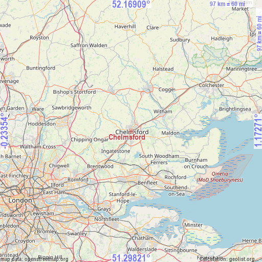
Chelmsford GPS coordinates[2]
51° 44' 8.7" North, 0° 28' 10.488" East
| Map corner | latitude | longitude |
|---|---|---|
| Upper-left | 52.16909°, | -0.23354° |
| Center: | 51.73575°, | 0.46958° |
| Lower-right: | 51.29821°, | 1.17271° |
| Map W x H: | 96.8×96.8 km | = 60.1×60.1mi |
| max Lat: | 60.39635° ⇑69.8% North |
| Chelmsford: | 51.73575° |
| min Lat: | ⇓30.2% South 34.60088° |
| min Long | Chelmsford | max Long |
| -7.64133° | 0.46958° | 32.95536° |
| W 92%⇐ | ⇒8% E |
Elevation
Elevation of Chelmsford is 33 m = 108 ft, and this is 39.9 m = 131 ft below average elevation for this country.
| Max E: |
515 m = 1690 ft | 70% |
| Avg. | 72.9 m = 239 ft | |
| Chelmsford | 33 m = 108 ft | |
Min E: |
-30 m = -98 ft | 30% |
See also: Chelmsford elevation on elevation.city.
Geographical zone
Chelmsford is located in North temperate zone (between Tropic of Cancer and the Arctic Circle). Distance of this North polar circle is 1648.7 km =1024.5 mi to North.| Distance of | km | miles | from Chelmsford |
|---|---|---|---|
| North Pole | 4254.6 | 2643.7 | to North |
| Arctic Circle | 1648.7 | 1024.5 | to North |
| Tropic Cancer | 3146.6 | 1955.2 | to South |
| Equator | 5752.5 | 3574.4 | to South |


Nearby cities:
15 places around Chelmsford: (largest is in red/bold)
• Bicknacre
9.2 km =5.7 mi,  120°
120°
• Blackmore
11.5 km =7.1 mi,  245°
245°
• Boreham
5.6 km =3.5 mi,  61°
61°
• Danbury
8.1 km =5 mi,  105°
105°
• East Hanningfield
8.5 km =5.3 mi,  133°
133°
• Ford End
10.3 km =6.4 mi,  345°
345°
• Great Leighs
10.5 km =6.5 mi,  13°
13°
• Great Waltham
6.5 km =4 mi, 352°
• Hatfield Peverel
9.7 km =6 mi, 62°
• High Easter
11.6 km =7.2 mi,  314°
314°
• Ingatestone
9.4 km =5.8 mi,  219°
219°
• Margaretting
6.3 km =3.9 mi, 216°
• Stock
8.2 km =5.1 mi,  193°
193°
• Woodham Mortimer
11 km =6.8 mi, 105°
• Writtle
2.9 km =1.8 mi, 254°
Sources, notices
• [Note1] Compared only with cities in United Kingdom existing in our database
• [Src1] Map data: © OpenStreetMap contributors (CC-BY-SA)
• [Src2] Other city data from geonames.org with taken over terms of usage.
• [Src3] Geographical zone / Annual Mean Temperature by Robert A. Rohde @ Wikipedia
