Chatham geodata
Chatham (England) is a populated place; located in United Kingdom in Europe/London (GMT+1) time zone. With population of 75,509 people, there are 138 cities with bigger population in this country. Compared to other cities in United Kingdom, 81.6% of cities are located further ↑North; 92.6% of cities are located further ←West and 79.9% of cities have higher elevation than Chatham. Note1


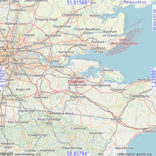
Chatham GPS coordinates[2]
51° 22' 44.076" North, 0° 31' 40.296" East
| Map corner | latitude | longitude |
|---|---|---|
| Upper-left | 51.81568°, | -0.17527° |
| Center: | 51.37891°, | 0.52786° |
| Lower-right: | 50.93794°, | 1.23098° |
| Map W x H: | 97.6×97.6 km | = 60.6×60.6mi |
| max Lat: | 60.39635° ⇑81.6% North |
| Chatham: | 51.37891° |
| min Lat: | ⇓18.4% South 34.60088° |
| min Long | Chatham | max Long |
| -7.64133° | 0.52786° | 32.95536° |
| W 92.6%⇐ | ⇒7.4% E |
Elevation
Elevation of Chatham is 21 m = 69 ft, and this is 51.9 m = 170 ft below average elevation for this country.
| Max E: |
515 m = 1690 ft | 79.9% |
| Avg. | 72.9 m = 239 ft | |
| Chatham | 21 m = 69 ft | |
Min E: |
-30 m = -98 ft | 20.1% |
See also: Chatham elevation on elevation.city.
Geographical zone
Chatham is located in North temperate zone (between Tropic of Cancer and the Arctic Circle). Distance of this North polar circle is 1688.4 km =1049.1 mi to North.| Distance of | km | miles | from Chatham |
|---|---|---|---|
| North Pole | 4294.3 | 2668.4 | to North |
| Arctic Circle | 1688.4 | 1049.1 | to North |
| Tropic Cancer | 3106.9 | 1930.5 | to South |
| Equator | 5712.8 | 3549.8 | to South |


Nearby cities:
15 places around Chatham: (largest is in red/bold)
• Boxley
8.6 km =5.3 mi,  173°
173°
• Burham
6.2 km =3.9 mi,  213°
213°
• Chattenden
4.4 km =2.7 mi,  1°
1°
• Cooling
8.4 km =5.2 mi,  358°
358°
• Cuxton
5 km =3.1 mi,  264°
264°
• Gillingham
1.8 km =1.1 mi,  51°
51°
• Halling
6.5 km =4 mi,  241°
241°
• High Halstow
7.9 km =4.9 mi,  14°
14°
• Hoo
5.2 km =3.2 mi,  27°
27°
• Rainham
5.9 km =3.7 mi,  107°
107°
• Rochester
1.8 km =1.1 mi,  301°
301°
• Snodland
8 km =5 mi,  227°
227°
• Strood
3.9 km =2.4 mi,  294°
294°
• Upchurch
8.3 km =5.2 mi,  92°
92°
• Wouldham
5.8 km =3.6 mi, 236°
Sources, notices
• [Note1] Compared only with cities in United Kingdom existing in our database
• [Src1] Map data: © OpenStreetMap contributors (CC-BY-SA)
• [Src2] Other city data from geonames.org with taken over terms of usage.
• [Src3] Geographical zone / Annual Mean Temperature by Robert A. Rohde @ Wikipedia
