Chagford geodata
Chagford (England) is a populated place; located in United Kingdom in Europe/London (GMT+1) time zone. With population of 1,020 people, there are 3599 cities with bigger population in this country. Compared to other cities in United Kingdom, 96.8% of cities are located further ↑North; 86.3% of cities are located further →East and 94.1% of cities have lower elevation than Chagford. Note1
Administrative division(s):
- Level 1: England
- Level 2: Devon
- Level 3: West Devon District
- Level 4: Chagford


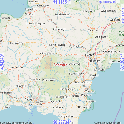
Chagford GPS coordinates[2]
50° 40' 30.144" North, 3° 50' 21.696" West
| Map corner | latitude | longitude |
|---|---|---|
| Upper-left | 51.11851°, | -4.54249° |
| Center: | 50.67504°, | -3.83936° |
| Lower-right: | 50.22734°, | -3.13624° |
| Map W x H: | 99.1×99.1 km | = 61.6×61.6mi |
| max Lat: | 60.39635° ⇑96.8% North |
| Chagford: | 50.67504° |
| min Lat: | ⇓3.2% South 34.60088° |
| min Long | Chagford | max Long |
| -7.64133° | -3.83936° | 32.95536° |
| W 13.7%⇐ | ⇒86.3% E |
Elevation
Elevation of Chagford is 175 m = 574 ft, and this is 102.1 m = 335 ft above average elevation for this country.
| Max E: |
515 m = 1690 ft | 5.9% |
| Chagford | 175 m 574 ft | |
| Avg. | 72.9 m = 239 ft | |
Min E: |
-30 m = -98 ft | 94.1% |
See also: United Kingdom elevation on elevation.city.
Geographical zone
Chagford is located in North temperate zone (between Tropic of Cancer and the Arctic Circle). Distance of this North polar circle is 1766.6 km =1097.7 mi to North.| Distance of | km | miles | from Chagford |
|---|---|---|---|
| North Pole | 4372.5 | 2716.9 | to North |
| Arctic Circle | 1766.6 | 1097.7 | to North |
| Tropic Cancer | 3028.6 | 1881.9 | to South |
| Equator | 5634.5 | 3501.1 | to South |


Nearby cities:
15 places around Chagford: (largest is in red/bold)
• Ashburton
18.7 km =11.6 mi,  161°
161°
• Bovey Tracey
14.8 km =9.2 mi,  128°
128°
• Bow
14 km =8.7 mi,  6°
6°
• Cheriton Bishop
8.8 km =5.5 mi,  51°
51°
• Christow
13.7 km =8.5 mi,  100°
100°
• Chudleigh
18.6 km =11.6 mi,  114°
114°
• Chudleigh Knighton
17.7 km =11 mi,  124°
124°
• Copplestone
16.5 km =10.3 mi,  23°
23°
• Crediton
18 km =11.2 mi, 47°
• Moretonhampstead
5.5 km =3.4 mi, 106°
• North Tawton
14.5 km =9 mi,  343°
343°
• Okehampton
13.4 km =8.3 mi,  301°
301°
• Princetown
18 km =11.2 mi,  215°
215°
• Sandford
19.4 km =12.1 mi,  39°
39°
• South Zeal
7.7 km =4.8 mi,  317°
317°
Sources, notices
• [Note1] Compared only with cities in United Kingdom existing in our database
• [Src1] Map data: © OpenStreetMap contributors (CC-BY-SA)
• [Src2] Other city data from geonames.org with taken over terms of usage.
• [Src3] Geographical zone / Annual Mean Temperature by Robert A. Rohde @ Wikipedia
