Castle Camps geodata
Castle Camps (England) is a populated place; located in United Kingdom in Europe/London (GMT+1) time zone. With population of 684 people, there are 4317 cities with bigger population in this country. Compared to other cities in United Kingdom, 60.3% of cities are located further ↑North; 91.1% of cities are located further ←West and 82.5% of cities have lower elevation than Castle Camps. Note1
Administrative division(s):
- Level 1: England
- Level 2: Cambridgeshire
- Level 3: South Cambridgeshire District
- Level 4: Castle Camps


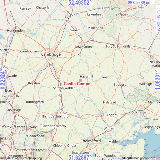
Castle Camps GPS coordinates[2]
52° 3' 48.024" North, 0° 22' 47.604" East
| Map corner | latitude | longitude |
|---|---|---|
| Upper-left | 52.49352°, | -0.32324° |
| Center: | 52.06334°, | 0.37989° |
| Lower-right: | 51.62897°, | 1.08301° |
| Map W x H: | 96.1×96.1 km | = 59.7×59.7mi |
| max Lat: | 60.39635° ⇑60.3% North |
| Castle Camps: | 52.06334° |
| min Lat: | ⇓39.7% South 34.60088° |
| min Long | Castle Camps | max Long |
| -7.64133° | 0.37989° | 32.95536° |
| W 91.1%⇐ | ⇒8.9% E |
Elevation
Elevation of Castle Camps is 125 m = 410 ft, and this is 52.1 m = 171 ft above average elevation for this country.
| Max E: |
515 m = 1690 ft | 17.5% |
| Castle Camps | 125 m 410 ft | |
| Avg. | 72.9 m = 239 ft | |
Min E: |
-30 m = -98 ft | 82.5% |
See also: United Kingdom elevation on elevation.city.
Geographical zone
Castle Camps is located in North temperate zone (between Tropic of Cancer and the Arctic Circle). Distance of this North polar circle is 1612.3 km =1001.8 mi to North.| Distance of | km | miles | from Castle Camps |
|---|---|---|---|
| North Pole | 4218.2 | 2621.1 | to North |
| Arctic Circle | 1612.3 | 1001.8 | to North |
| Tropic Cancer | 3183 | 1977.8 | to South |
| Equator | 5788.9 | 3597.1 | to South |


Nearby cities:
15 places around Castle Camps: (largest is in red/bold)
• Ashdon
4.7 km =2.9 mi,  258°
258°
• Balsham
8.8 km =5.5 mi,  330°
330°
• Finchingfield
11.6 km =7.2 mi,  155°
155°
• Great Sampford
7.9 km =4.9 mi,  174°
174°
• Haverhill
4.5 km =2.8 mi,  62°
62°
• Hundon
11.9 km =7.4 mi, 64°
• Kedington
8 km =5 mi,  65°
65°
• Linton
8 km =5 mi,  298°
298°
• Littlebury
12.1 km =7.5 mi,  254°
254°
• Ridgewell
10.7 km =6.6 mi,  104°
104°
• Saffron Walden
10.4 km =6.5 mi,  244°
244°
• Steeple Bumpstead
5.2 km =3.2 mi,  115°
115°
• Stoke by Clare
10.8 km =6.7 mi,  90°
90°
• Thaxted
12.5 km =7.8 mi,  191°
191°
• West Wratting
9.1 km =5.7 mi,  345°
345°
Sources, notices
• [Note1] Compared only with cities in United Kingdom existing in our database
• [Src1] Map data: © OpenStreetMap contributors (CC-BY-SA)
• [Src2] Other city data from geonames.org with taken over terms of usage.
• [Src3] Geographical zone / Annual Mean Temperature by Robert A. Rohde @ Wikipedia
