Cambridge geodata
Cambridge (England) is a seat of a second-order administrative division; located in United Kingdom in Europe/London (GMT+1) time zone. With population of 158,434 people, there are 55 cities with bigger population in this country. Compared to other cities in United Kingdom, 56.5% of cities are located further ↑North; 88.1% of cities are located further ←West and 89.9% of cities have higher elevation than Cambridge. Note1


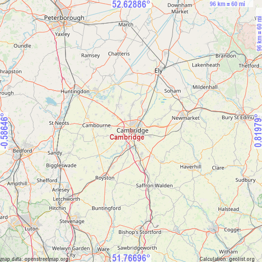
Cambridge GPS coordinates[2]
52° 12' 0" North, 0° 7' 0.012" East
| Map corner | latitude | longitude |
|---|---|---|
| Upper-left | 52.62886°, | -0.58646° |
| Center: | 52.2°, | 0.11667° |
| Lower-right: | 51.76696°, | 0.81979° |
| Map W x H: | 95.8×95.8 km | = 59.5×59.5mi |
| max Lat: | 60.39635° ⇑56.5% North |
| Cambridge: | 52.2° |
| min Lat: | ⇓43.5% South 34.60088° |
| min Long | Cambridge | max Long |
| -7.64133° | 0.11667° | 32.95536° |
| W 88.1%⇐ | ⇒11.9% E |
Elevation
Elevation of Cambridge is 12 m = 39 ft, and this is 60.9 m = 200 ft below average elevation for this country.
| Max E: |
515 m = 1690 ft | 89.9% |
| Avg. | 72.9 m = 239 ft | |
| Cambridge | 12 m = 39 ft | |
Min E: |
-30 m = -98 ft | 10.1% |
See also: Cambridge elevation on elevation.city.
Geographical zone
Cambridge is located in North temperate zone (between Tropic of Cancer and the Arctic Circle). Distance of this North polar circle is 1597.1 km =992.4 mi to North.| Distance of | km | miles | from Cambridge |
|---|---|---|---|
| North Pole | 4203 | 2611.6 | to North |
| Arctic Circle | 1597.1 | 992.4 | to North |
| Tropic Cancer | 3198.2 | 1987.3 | to South |
| Equator | 5804.1 | 3606.5 | to South |


Nearby cities:
15 places around Cambridge: (largest is in red/bold)
• Bar Hill
8.1 km =5 mi,  312°
312°
• Barton
4.4 km =2.7 mi,  245°
245°
• Comberton
6.8 km =4.2 mi,  257°
257°
• Coton
4 km =2.5 mi,  287°
287°
• Dry Drayton
8.2 km =5.1 mi,  304°
304°
• Fulbourn
7.3 km =4.5 mi,  105°
105°
• Girton
4.3 km =2.7 mi,  328°
328°
• Grantchester
2.8 km =1.7 mi,  219°
219°
• Harston
7.4 km =4.6 mi,  199°
199°
• Haslingfield
6.9 km =4.3 mi, 216°
• Hauxton
5.8 km =3.6 mi,  190°
190°
• Histon
5.8 km =3.6 mi,  353°
353°
• Oakington
7.5 km =4.7 mi, 333°
• Stow cum Quy
7.8 km =4.8 mi,  70°
70°
• Waterbeach
8.9 km =5.5 mi,  34°
34°
Sources, notices
• [Note1] Compared only with cities in United Kingdom existing in our database
• [Src1] Map data: © OpenStreetMap contributors (CC-BY-SA)
• [Src2] Other city data from geonames.org with taken over terms of usage.
• [Src3] Geographical zone / Annual Mean Temperature by Robert A. Rohde @ Wikipedia
