Burnham-on-Sea geodata
Burnham-on-Sea (England) is a populated place; located in United Kingdom in Europe/London (GMT+1) time zone. With population of 23,325 people, there are 513 cities with bigger population in this country. Compared to other cities in United Kingdom, 85.8% of cities are located further ↑North; 75.1% of cities are located further →East and 93.6% of cities have higher elevation than Burnham-on-Sea. Note1
Administrative division(s):
- Level 1: England
- Level 2: Somerset
- Level 3: Sedgemoor District
- Level 4: Burnham-on-Sea and Highbridge


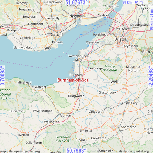
Burnham-on-Sea GPS coordinates[2]
51° 14' 19.032" North, 2° 59' 52.08" West
| Map corner | latitude | longitude |
|---|---|---|
| Upper-left | 51.67673°, | -3.70093° |
| Center: | 51.23862°, | -2.9978° |
| Lower-right: | 50.7963°, | -2.29468° |
| Map W x H: | 97.9×97.9 km | = 60.8×60.8mi |
| max Lat: | 60.39635° ⇑85.8% North |
| Burnham-on-Sea: | 51.23862° |
| min Lat: | ⇓14.2% South 34.60088° |
| min Long | Burnham-on-Sea | max Long |
| -7.64133° | -2.9978° | 32.95536° |
| W 24.9%⇐ | ⇒75.1% E |
Elevation
Elevation of Burnham-on-Sea is 9 m = 30 ft, and this is 63.9 m = 210 ft below average elevation for this country.
| Max E: |
515 m = 1690 ft | 93.6% |
| Avg. | 72.9 m = 239 ft | |
| Burnham-on-Sea | 9 m = 30 ft | |
Min E: |
-30 m = -98 ft | 6.4% |
See also: United Kingdom elevation on elevation.city.
Geographical zone
Burnham-on-Sea is located in North temperate zone (between Tropic of Cancer and the Arctic Circle). Distance of this North polar circle is 1704 km =1058.8 mi to North.| Distance of | km | miles | from Burnham-on-Sea |
|---|---|---|---|
| North Pole | 4309.9 | 2678 | to North |
| Arctic Circle | 1704 | 1058.8 | to North |
| Tropic Cancer | 3091.3 | 1920.8 | to South |
| Equator | 5697.2 | 3540.1 | to South |


Nearby cities:
15 places around Burnham-on-Sea: (largest is in red/bold)
• Blackford
10.5 km =6.5 mi,  97°
97°
• Bleadon
8.5 km =5.3 mi,  24°
24°
• Brent Knoll
3.2 km =2 mi,  61°
61°
• Cossington
10.4 km =6.5 mi,  148°
148°
• East Brent
5.2 km =3.2 mi, 57°
• East Huntspill
5.7 km =3.5 mi,  134°
134°
• Edingworth
6.6 km =4.1 mi,  52°
52°
• Highbridge
2.6 km =1.6 mi,  157°
157°
• Huntspill
3.7 km =2.3 mi,  168°
168°
• Hutton
10.6 km =6.6 mi,  26°
26°
• Lympsham
5.9 km =3.7 mi, 31°
• Mark
7.6 km =4.7 mi, 99°
• Pawlett
6.5 km =4 mi,  182°
182°
• Puriton
7.9 km =4.9 mi, 166°
• Woolavington
9.2 km =5.7 mi, 153°
Sources, notices
• [Note1] Compared only with cities in United Kingdom existing in our database
• [Src1] Map data: © OpenStreetMap contributors (CC-BY-SA)
• [Src2] Other city data from geonames.org with taken over terms of usage.
• [Src3] Geographical zone / Annual Mean Temperature by Robert A. Rohde @ Wikipedia
