Bulford geodata
Bulford (England) is a seat of a third-order administrative division; located in United Kingdom in Europe/London (GMT+1) time zone. With population of 9,519 people, there are 1101 cities with bigger population in this country. Compared to other cities in United Kingdom, 87.1% of cities are located further ↑North; 50.3% of cities are located further →East and 62% of cities have lower elevation than Bulford. Note1


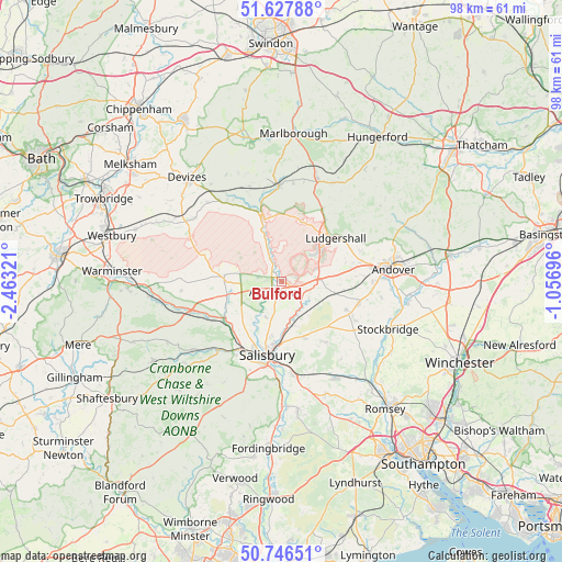
Bulford GPS coordinates[2]
51° 11' 21.48" North, 1° 45' 36.324" West
| Map corner | latitude | longitude |
|---|---|---|
| Upper-left | 51.62788°, | -2.46321° |
| Center: | 51.1893°, | -1.76009° |
| Lower-right: | 50.74651°, | -1.05696° |
| Map W x H: | 98×98 km | = 60.9×60.9mi |
| max Lat: | 60.39635° ⇑87.1% North |
| Bulford: | 51.1893° |
| min Lat: | ⇓12.9% South 34.60088° |
| min Long | Bulford | max Long |
| -7.64133° | -1.76009° | 32.95536° |
| W 49.7%⇐ | ⇒50.3% E |
Elevation
Elevation of Bulford is 80 m = 262 ft, and this is 7.1 m = 23 ft above average elevation for this country.
| Max E: |
515 m = 1690 ft | 38% |
| Bulford | 80 m 262 ft | |
| Avg. | 72.9 m = 239 ft | |
Min E: |
-30 m = -98 ft | 62% |
See also: United Kingdom elevation on elevation.city.
Geographical zone
Bulford is located in North temperate zone (between Tropic of Cancer and the Arctic Circle). Distance of this North polar circle is 1709.5 km =1062.2 mi to North.| Distance of | km | miles | from Bulford |
|---|---|---|---|
| North Pole | 4315.3 | 2681.4 | to North |
| Arctic Circle | 1709.5 | 1062.2 | to North |
| Tropic Cancer | 3085.8 | 1917.4 | to South |
| Equator | 5691.7 | 3536.7 | to South |


Nearby cities:
15 places around Bulford: (largest is in red/bold)
• Allington
6.1 km =3.8 mi,  136°
136°
• Amesbury
2.1 km =1.3 mi,  222°
222°
• Durnford
7.4 km =4.6 mi,  212°
212°
• Durrington
1.3 km =0.8 mi,  321°
321°
• Lark Hill
4.1 km =2.5 mi,  286°
286°
• Ludgershall
12.1 km =7.5 mi,  52°
52°
• Milston
2 km =1.2 mi,  341°
341°
• Netheravon
5.6 km =3.5 mi, 337°
• Old Sarum
9.9 km =6.2 mi,  190°
190°
• Over Wallop
12.5 km =7.8 mi,  112°
112°
• Rushall
11.2 km =7 mi, 339°
• Shrewton
9.9 km =6.2 mi,  271°
271°
• Tidworth
8.2 km =5.1 mi,  55°
55°
• Winterbourne Stoke
9.9 km =6.2 mi,  255°
255°
• Woodford
9.6 km =6 mi, 212°
Sources, notices
• [Note1] Compared only with cities in United Kingdom existing in our database
• [Src1] Map data: © OpenStreetMap contributors (CC-BY-SA)
• [Src2] Other city data from geonames.org with taken over terms of usage.
• [Src3] Geographical zone / Annual Mean Temperature by Robert A. Rohde @ Wikipedia
