Buckfastleigh geodata
Buckfastleigh (England) is a populated place; located in United Kingdom in Europe/London (GMT+1) time zone. With population of 3,631 people, there are 1945 cities with bigger population in this country. Compared to other cities in United Kingdom, 98.1% of cities are located further ↑North; 85.5% of cities are located further →East and 63.1% of cities have higher elevation than Buckfastleigh. Note1
Administrative division(s):
- Level 1: England
- Level 2: Devon
- Level 3: Teignbridge District
- Level 4: Buckfastleigh


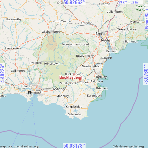
Buckfastleigh GPS coordinates[2]
50° 28' 52.752" North, 3° 46' 44.868" West
| Map corner | latitude | longitude |
|---|---|---|
| Upper-left | 50.92662°, | -4.48226° |
| Center: | 50.48132°, | -3.77913° |
| Lower-right: | 50.03178°, | -3.07601° |
| Map W x H: | 99.5×99.5 km | = 61.8×61.8mi |
| max Lat: | 60.39635° ⇑98.1% North |
| Buckfastleigh: | 50.48132° |
| min Lat: | ⇓1.9% South 34.60088° |
| min Long | Buckfastleigh | max Long |
| -7.64133° | -3.77913° | 32.95536° |
| W 14.5%⇐ | ⇒85.5% E |
Elevation
Elevation of Buckfastleigh is 42 m = 138 ft, and this is 30.9 m = 101 ft below average elevation for this country.
| Max E: |
515 m = 1690 ft | 63.1% |
| Avg. | 72.9 m = 239 ft | |
| Buckfastleigh | 42 m = 138 ft | |
Min E: |
-30 m = -98 ft | 36.9% |
See also: United Kingdom elevation on elevation.city.
Geographical zone
Buckfastleigh is located in North temperate zone (between Tropic of Cancer and the Arctic Circle). Distance of this North polar circle is 1788.2 km =1111.1 mi to North.| Distance of | km | miles | from Buckfastleigh |
|---|---|---|---|
| North Pole | 4394.1 | 2730.4 | to North |
| Arctic Circle | 1788.2 | 1111.1 | to North |
| Tropic Cancer | 3007.1 | 1868.5 | to South |
| Equator | 5613 | 3487.8 | to South |


Nearby cities:
15 places around Buckfastleigh: (largest is in red/bold)
• Abbotskerswell
12.1 km =7.5 mi,  75°
75°
• Ashburton
4.2 km =2.6 mi,  23°
23°
• Bovey Tracey
14.4 km =8.9 mi,  30°
30°
• Broadhempston
6.3 km =3.9 mi,  87°
87°
• Chudleigh Knighton
15.5 km =9.6 mi,  42°
42°
• Dartington
6.4 km =4 mi,  130°
130°
• Denbury
8.9 km =5.5 mi,  70°
70°
• Ipplepen
10 km =6.2 mi, 84°
• Ivybridge
14.2 km =8.8 mi,  224°
224°
• Kingskerswell
14.1 km =8.8 mi, 81°
• Marldon
13.2 km =8.2 mi,  102°
102°
• Newton Abbot
12.9 km =8 mi, 66°
• South Brent
7.2 km =4.5 mi,  212°
212°
• Stoke Gabriel
14.2 km =8.8 mi, 127°
• Totnes
8.7 km =5.4 mi, 129°
Sources, notices
• [Note1] Compared only with cities in United Kingdom existing in our database
• [Src1] Map data: © OpenStreetMap contributors (CC-BY-SA)
• [Src2] Other city data from geonames.org with taken over terms of usage.
• [Src3] Geographical zone / Annual Mean Temperature by Robert A. Rohde @ Wikipedia
