Bryneglwys geodata
Bryneglwys (Wales) is a seat of a third-order administrative division; located in United Kingdom in Europe/London (GMT+1) time zone. In our database, there are 4977 cities with bigger population. Compared to other cities in United Kingdom, 60.8% of cities are located further ↓South; 79.4% of cities are located further →East and 98.9% of cities have lower elevation than Bryneglwys. Note1


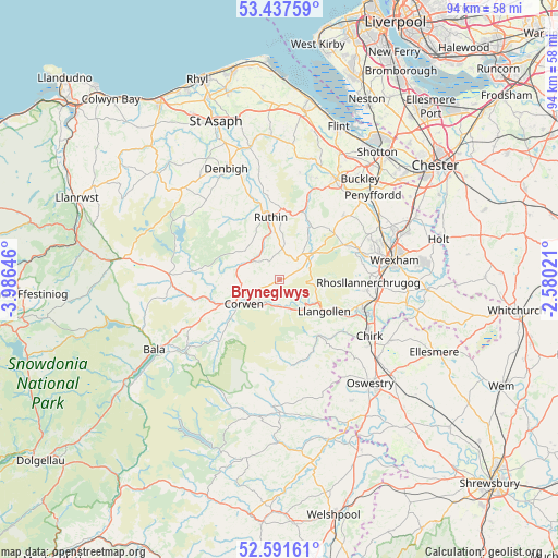
Bryneglwys GPS coordinates[2]
53° 1' 0.012" North, 3° 16' 59.988" West
| Map corner | latitude | longitude |
|---|---|---|
| Upper-left | 53.43759°, | -3.98646° |
| Center: | 53.01667°, | -3.28333° |
| Lower-right: | 52.59161°, | -2.58021° |
| Map W x H: | 94.1×94.1 km | = 58.5×58.5mi |
| max Lat: | 60.39635° ⇑39.2% North |
| Bryneglwys: | 53.01667° |
| min Lat: | ⇓60.8% South 34.60088° |
| min Long | Bryneglwys | max Long |
| -7.64133° | -3.28333° | 32.95536° |
| W 20.6%⇐ | ⇒79.4% E |
Elevation
Elevation of Bryneglwys is 247 m = 810 ft, and this is 174.1 m = 571 ft above average elevation for this country.
| Max E: |
515 m = 1690 ft | 1.1% |
| Bryneglwys | 247 m 810 ft | |
| Avg. | 72.9 m = 239 ft | |
Min E: |
-30 m = -98 ft | 98.9% |
See also: United Kingdom elevation on elevation.city.
Geographical zone
Bryneglwys is located in North temperate zone (between Tropic of Cancer and the Arctic Circle). Distance of this North polar circle is 1506.3 km =936 mi to North.| Distance of | km | miles | from Bryneglwys |
|---|---|---|---|
| North Pole | 4112.2 | 2555.2 | to North |
| Arctic Circle | 1506.3 | 936 | to North |
| Tropic Cancer | 3289 | 2043.7 | to South |
| Equator | 5894.9 | 3662.9 | to South |


Nearby cities:
15 places around Bryneglwys: (largest is in red/bold)
• Brymbo
15.5 km =9.6 mi,  69°
69°
• Chirk
17.6 km =10.9 mi,  120°
120°
• Coedpoeth
15.3 km =9.5 mi, 74°
• Cynwyd
10.4 km =6.5 mi,  232°
232°
• Derwen
8 km =5 mi,  283°
283°
• Leeswood
18.1 km =11.2 mi,  44°
44°
• Llandegla
7.4 km =4.6 mi,  50°
50°
• Llandrillo
14.7 km =9.1 mi,  224°
224°
• Llandyrnog
18 km =11.2 mi,  348°
348°
• Llangollen
9.2 km =5.7 mi,  125°
125°
• Llangwm
17.1 km =10.6 mi,  257°
257°
• Rhosllanerchrugog
15.1 km =9.4 mi,  92°
92°
• Ruabon
16.7 km =10.4 mi,  101°
101°
• Ruthin
11 km =6.8 mi, 347°
• Treuddyn
15.4 km =9.6 mi, 44°
Sources, notices
• [Note1] Compared only with cities in United Kingdom existing in our database
• [Src1] Map data: © OpenStreetMap contributors (CC-BY-SA)
• [Src2] Other city data from geonames.org with taken over terms of usage.
• [Src3] Geographical zone / Annual Mean Temperature by Robert A. Rohde @ Wikipedia
