Bradford geodata
Bradford (England) is a seat of a second-order administrative division; located in United Kingdom in Europe/London (GMT+1) time zone. With population of 299,310 people, there are 23 cities with bigger population in this country. Compared to other cities in United Kingdom, 75.6% of cities are located further ↓South; 50.2% of cities are located further →East and 76.5% of cities have lower elevation than Bradford. Note1


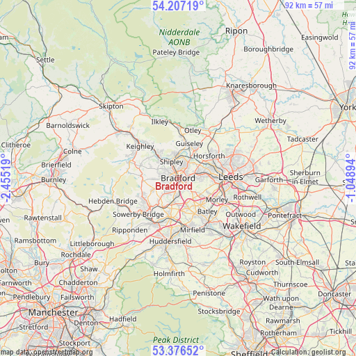
Bradford GPS coordinates[2]
53° 47' 38.076" North, 1° 45' 7.416" West
| Map corner | latitude | longitude |
|---|---|---|
| Upper-left | 54.20719°, | -2.45519° |
| Center: | 53.79391°, | -1.75206° |
| Lower-right: | 53.37652°, | -1.04894° |
| Map W x H: | 92.4×92.4 km | = 57.4×57.4mi |
| max Lat: | 60.39635° ⇑24.4% North |
| Bradford: | 53.79391° |
| min Lat: | ⇓75.6% South 34.60088° |
| min Long | Bradford | max Long |
| -7.64133° | -1.75206° | 32.95536° |
| W 49.8%⇐ | ⇒50.2% E |
Elevation
Elevation of Bradford is 110 m = 361 ft, and this is 37.1 m = 122 ft above average elevation for this country.
| Max E: |
515 m = 1690 ft | 23.5% |
| Bradford | 110 m 361 ft | |
| Avg. | 72.9 m = 239 ft | |
Min E: |
-30 m = -98 ft | 76.5% |
See also: Bradford elevation on elevation.city.
Geographical zone
Bradford is located in North temperate zone (between Tropic of Cancer and the Arctic Circle). Distance of this North polar circle is 1419.9 km =882.3 mi to North.| Distance of | km | miles | from Bradford |
|---|---|---|---|
| North Pole | 4025.7 | 2501.5 | to North |
| Arctic Circle | 1419.9 | 882.3 | to North |
| Tropic Cancer | 3375.4 | 2097.4 | to South |
| Equator | 5981.3 | 3716.6 | to South |


Nearby cities:
15 places around Bradford: (largest is in red/bold)
• Baildon
6.4 km =4 mi,  338°
338°
• Bingley
8.3 km =5.2 mi,  316°
316°
• Clayton
5.2 km =3.2 mi,  234°
234°
• Cleckheaton
8.2 km =5.1 mi,  161°
161°
• Cullingworth
10.1 km =6.3 mi,  289°
289°
• Denholme
9.4 km =5.8 mi,  275°
275°
• Drighlington
7.1 km =4.4 mi,  126°
126°
• Gildersome
8.7 km =5.4 mi,  114°
114°
• Guiseley
9.5 km =5.9 mi,  16°
16°
• Horsforth
9.3 km =5.8 mi,  54°
54°
• Pudsey
6 km =3.7 mi,  88°
88°
• Queensbury
7.1 km =4.4 mi,  244°
244°
• Shipley
4.5 km =2.8 mi,  347°
347°
• Wilsden
7.7 km =4.8 mi, 292°
• Yeadon
8.9 km =5.5 mi,  28°
28°
Sources, notices
• [Note1] Compared only with cities in United Kingdom existing in our database
• [Src1] Map data: © OpenStreetMap contributors (CC-BY-SA)
• [Src2] Other city data from geonames.org with taken over terms of usage.
• [Src3] Geographical zone / Annual Mean Temperature by Robert A. Rohde @ Wikipedia
