Bolton upon Dearne geodata
Bolton upon Dearne (England) is a populated place; located in United Kingdom in Europe/London (GMT+1) time zone. With population of 13,236 people, there are 854 cities with bigger population in this country. Compared to other cities in United Kingdom, 70.2% of cities are located further ↓South; 59.8% of cities are located further ←West and 71.6% of cities have higher elevation than Bolton upon Dearne. Note1


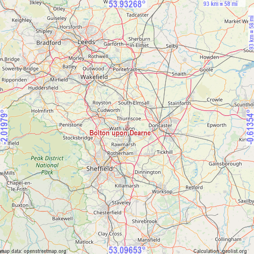
Bolton upon Dearne GPS coordinates[2]
53° 31' 0.012" North, 1° 19' 0.012" West
| Map corner | latitude | longitude |
|---|---|---|
| Upper-left | 53.93268°, | -2.01979° |
| Center: | 53.51667°, | -1.31667° |
| Lower-right: | 53.09653°, | -0.61354° |
| Map W x H: | 93×93 km | = 57.8×57.8mi |
| max Lat: | 60.39635° ⇑29.8% North |
| Bolton upon Dearne: | 53.51667° |
| min Lat: | ⇓70.2% South 34.60088° |
| min Long | Bolton upon Dea | max Long |
| -7.64133° | -1.31667° | 32.95536° |
| W 59.8%⇐ | ⇒40.2% E |
Elevation
Elevation of Bolton upon Dearne is 31 m = 102 ft, and this is 41.9 m = 137 ft below average elevation for this country.
| Max E: |
515 m = 1690 ft | 71.6% |
| Avg. | 72.9 m = 239 ft | |
| Bolton upon Dearne | 31 m = 102 ft | |
Min E: |
-30 m = -98 ft | 28.4% |
See also: United Kingdom elevation on elevation.city.
Geographical zone
Bolton upon Dearne is located in North temperate zone (between Tropic of Cancer and the Arctic Circle). Distance of this North polar circle is 1450.7 km =901.4 mi to North.| Distance of | km | miles | from Bolton upon Dearne |
|---|---|---|---|
| North Pole | 4056.6 | 2520.7 | to North |
| Arctic Circle | 1450.7 | 901.4 | to North |
| Tropic Cancer | 3344.6 | 2078.2 | to South |
| Equator | 5950.5 | 3697.5 | to South |


Nearby cities:
15 places around Bolton upon Dearne: (largest is in red/bold)
• Barnburgh
3 km =1.9 mi,  74°
74°
• Conisbrough
6.8 km =4.2 mi,  124°
124°
• Cudworth
8.9 km =5.5 mi,  312°
312°
• Darfield
4.4 km =2.7 mi,  296°
296°
• Great Houghton
4.6 km =2.9 mi,  332°
332°
• Grimethorpe
7.8 km =4.8 mi, 329°
• Hoyland Nether
9 km =5.6 mi,  258°
258°
• Little Houghton
4.3 km =2.7 mi,  318°
318°
• Marr
7 km =4.3 mi, 65°
• Mexborough
3 km =1.9 mi,  147°
147°
• Rawmarsh
6.5 km =4 mi,  196°
196°
• South Elmsall
9.3 km =5.8 mi,  15°
15°
• Wath upon Dearne
2.5 km =1.6 mi,  231°
231°
• Wentworth
7.8 km =4.8 mi,  236°
236°
• Wombwell
5.3 km =3.3 mi,  276°
276°
Sources, notices
• [Note1] Compared only with cities in United Kingdom existing in our database
• [Src1] Map data: © OpenStreetMap contributors (CC-BY-SA)
• [Src2] Other city data from geonames.org with taken over terms of usage.
• [Src3] Geographical zone / Annual Mean Temperature by Robert A. Rohde @ Wikipedia
