Bloxwich geodata
Bloxwich (England) is a populated place; located in United Kingdom in Europe/London (GMT+1) time zone. With population of 40,000 people, there are 302 cities with bigger population in this country. Compared to other cities in United Kingdom, 52.9% of cities are located further ↓South; 54.9% of cities are located further →East and 93% of cities have lower elevation than Bloxwich. Note1


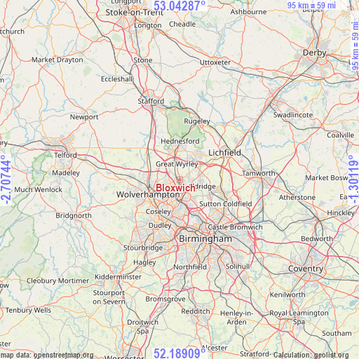
Bloxwich GPS coordinates[2]
52° 37' 5.016" North, 2° 0' 15.516" West
| Map corner | latitude | longitude |
|---|---|---|
| Upper-left | 53.04287°, | -2.70744° |
| Center: | 52.61806°, | -2.00431° |
| Lower-right: | 52.18909°, | -1.30119° |
| Map W x H: | 94.9×94.9 km | = 59×59mi |
| max Lat: | 60.39635° ⇑47.1% North |
| Bloxwich: | 52.61806° |
| min Lat: | ⇓52.9% South 34.60088° |
| min Long | Bloxwich | max Long |
| -7.64133° | -2.00431° | 32.95536° |
| W 45.1%⇐ | ⇒54.9% E |
Elevation
Elevation of Bloxwich is 166 m = 545 ft, and this is 93.1 m = 305 ft above average elevation for this country.
| Max E: |
515 m = 1690 ft | 7% |
| Bloxwich | 166 m 545 ft | |
| Avg. | 72.9 m = 239 ft | |
Min E: |
-30 m = -98 ft | 93% |
See also: Bloxwich elevation on elevation.city.
Geographical zone
Bloxwich is located in North temperate zone (between Tropic of Cancer and the Arctic Circle). Distance of this North polar circle is 1550.6 km =963.5 mi to North.| Distance of | km | miles | from Bloxwich |
|---|---|---|---|
| North Pole | 4156.5 | 2582.7 | to North |
| Arctic Circle | 1550.6 | 963.5 | to North |
| Tropic Cancer | 3244.7 | 2016.2 | to South |
| Equator | 5850.6 | 3635.4 | to South |


Nearby cities:
15 places around Bloxwich: (largest is in red/bold)
• Aldridge
6 km =3.7 mi,  103°
103°
• Bilston
7.5 km =4.7 mi,  218°
218°
• Brownhills
5.1 km =3.2 mi,  70°
70°
• Chasetown
8 km =5 mi,  41°
41°
• Darlaston
6 km =3.7 mi,  198°
198°
• Essington
3.8 km =2.4 mi,  288°
288°
• Featherstone
6.7 km =4.2 mi,  296°
296°
• Great Wyrley
5 km =3.1 mi,  354°
354°
• Norton Canes
6.6 km =4.1 mi,  25°
25°
• Pelsall
2.8 km =1.7 mi,  63°
63°
• Shareshill
6.7 km =4.2 mi,  309°
309°
• Walsall
3.9 km =2.4 mi,  159°
159°
• Wednesbury
7.5 km =4.7 mi,  189°
189°
• Wednesfield
6 km =3.7 mi,  246°
246°
• Willenhall
5.2 km =3.2 mi,  225°
225°
Sources, notices
• [Note1] Compared only with cities in United Kingdom existing in our database
• [Src1] Map data: © OpenStreetMap contributors (CC-BY-SA)
• [Src2] Other city data from geonames.org with taken over terms of usage.
• [Src3] Geographical zone / Annual Mean Temperature by Robert A. Rohde @ Wikipedia
