Bishops Stortford geodata
Bishops Stortford (England) is a populated place; located in United Kingdom in Europe/London (GMT+1) time zone. With population of 37,838 people, there are 319 cities with bigger population in this country. Compared to other cities in United Kingdom, 65.8% of cities are located further ↑North; 88.5% of cities are located further ←West and 55.8% of cities have lower elevation than Bishops Stortford. Note1
Administrative division(s):
- Level 1: England
- Level 2: Hertfordshire
- Level 3: East Hertfordshire District
- Level 4: Bishop's Stortford


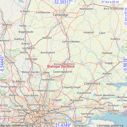
Bishops Stortford GPS coordinates[2]
51° 52' 16.068" North, 0° 9' 31.248" East
| Map corner | latitude | longitude |
|---|---|---|
| Upper-left | 52.30317°, | -0.54445° |
| Center: | 51.87113°, | 0.15868° |
| Lower-right: | 51.4349°, | 0.8618° |
| Map W x H: | 96.5×96.5 km | = 60×60mi |
| max Lat: | 60.39635° ⇑65.8% North |
| Bishops Stortford: | 51.87113° |
| min Lat: | ⇓34.2% South 34.60088° |
| min Long | Bishops Stortfo | max Long |
| -7.64133° | 0.15868° | 32.95536° |
| W 88.5%⇐ | ⇒11.5% E |
Elevation
Elevation of Bishops Stortford is 70 m = 230 ft, and this is 2.9 m = 10 ft below average elevation for this country.
| Max E: |
515 m = 1690 ft | 44.2% |
| Avg. | 72.9 m = 239 ft | |
| Bishops Stortford | 70 m = 230 ft | |
Min E: |
-30 m = -98 ft | 55.8% |
See also: United Kingdom elevation on elevation.city.
Geographical zone
Bishops Stortford is located in North temperate zone (between Tropic of Cancer and the Arctic Circle). Distance of this North polar circle is 1633.6 km =1015.1 mi to North.| Distance of | km | miles | from Bishops Stortford |
|---|---|---|---|
| North Pole | 4239.5 | 2634.3 | to North |
| Arctic Circle | 1633.6 | 1015.1 | to North |
| Tropic Cancer | 3161.6 | 1964.5 | to South |
| Equator | 5767.5 | 3583.8 | to South |


Nearby cities:
15 places around Bishops Stortford: (largest is in red/bold)
• Birchanger
2.7 km =1.7 mi,  58°
58°
• Elsenham
6.8 km =4.2 mi,  45°
45°
• Furneux Pelham
8.6 km =5.3 mi,  321°
321°
• Hatfield Broad Oak
7.8 km =4.8 mi,  129°
129°
• Hatfield Heath
7.5 km =4.7 mi,  150°
150°
• Henham
9.2 km =5.7 mi,  41°
41°
• Little Hallingbury
4.5 km =2.8 mi,  159°
159°
• Manuden
5.3 km =3.3 mi,  6°
6°
• Much Hadham
6.3 km =3.9 mi,  252°
252°
• Rickling Green
8.8 km =5.5 mi,  16°
16°
• Sawbridgeworth
6.1 km =3.8 mi,  185°
185°
• Sheering
7.7 km =4.8 mi,  166°
166°
• Stansted Mountfitchet
4.3 km =2.7 mi, 41°
• Takeley
7.4 km =4.6 mi,  90°
90°
• Widford
8.7 km =5.4 mi,  232°
232°
In other languages:
- In Spanish: Bishop’s Stortford
- In German: Bishop’s Stortford
- In Chinese: 畢曉普斯托福德
Sources, notices
• [Note1] Compared only with cities in United Kingdom existing in our database
• [Src1] Map data: © OpenStreetMap contributors (CC-BY-SA)
• [Src2] Other city data from geonames.org with taken over terms of usage.
• [Src3] Geographical zone / Annual Mean Temperature by Robert A. Rohde @ Wikipedia
