Bedford geodata
Bedford (England) is a seat of a second-order administrative division; located in United Kingdom in Europe/London (GMT+1) time zone. With population of 106,940 people, there are 90 cities with bigger population in this country. Compared to other cities in United Kingdom, 58.1% of cities are located further ↑North; 77.4% of cities are located further ←West and 72.3% of cities have higher elevation than Bedford. Note1


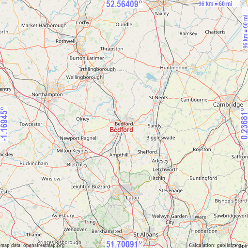
Bedford GPS coordinates[2]
52° 8' 4.524" North, 0° 27' 58.752" West
| Map corner | latitude | longitude |
|---|---|---|
| Upper-left | 52.56409°, | -1.16945° |
| Center: | 52.13459°, | -0.46632° |
| Lower-right: | 51.70091°, | 0.23681° |
| Map W x H: | 96×96 km | = 59.7×59.7mi |
| max Lat: | 60.39635° ⇑58.1% North |
| Bedford: | 52.13459° |
| min Lat: | ⇓41.9% South 34.60088° |
| min Long | Bedford | max Long |
| -7.64133° | -0.46632° | 32.95536° |
| W 77.4%⇐ | ⇒22.6% E |
Elevation
Elevation of Bedford is 30 m = 98 ft, and this is 42.9 m = 141 ft below average elevation for this country.
| Max E: |
515 m = 1690 ft | 72.3% |
| Avg. | 72.9 m = 239 ft | |
| Bedford | 30 m = 98 ft | |
Min E: |
-30 m = -98 ft | 27.7% |
See also: Bedford elevation on elevation.city.
Geographical zone
Bedford is located in North temperate zone (between Tropic of Cancer and the Arctic Circle). Distance of this North polar circle is 1604.4 km =996.9 mi to North.| Distance of | km | miles | from Bedford |
|---|---|---|---|
| North Pole | 4210.2 | 2616.1 | to North |
| Arctic Circle | 1604.4 | 996.9 | to North |
| Tropic Cancer | 3190.9 | 1982.7 | to South |
| Equator | 5796.8 | 3602 | to South |


Nearby cities:
15 places around Bedford: (largest is in red/bold)
• Biddenham
2.8 km =1.7 mi,  278°
278°
• Bromham
4.4 km =2.7 mi,  285°
285°
• Cardington
4.1 km =2.5 mi,  117°
117°
• Clapham
3.5 km =2.2 mi,  325°
325°
• Cople
5.4 km =3.4 mi,  103°
103°
• Cotton End
5.5 km =3.4 mi,  142°
142°
• Elstow
3 km =1.9 mi,  178°
178°
• Kempston
3.1 km =1.9 mi,  228°
228°
• Kempston Hardwick
5.5 km =3.4 mi,  204°
204°
• Oakley
5.6 km =3.5 mi,  312°
312°
• Stagsden
6.9 km =4.3 mi,  266°
266°
• Stevington
7.1 km =4.4 mi,  301°
301°
• Willington
6.4 km =4 mi,  90°
90°
• Wilstead
6.1 km =3.8 mi,  168°
168°
• Wootton
6.4 km =4 mi, 226°
Sources, notices
• [Note1] Compared only with cities in United Kingdom existing in our database
• [Src1] Map data: © OpenStreetMap contributors (CC-BY-SA)
• [Src2] Other city data from geonames.org with taken over terms of usage.
• [Src3] Geographical zone / Annual Mean Temperature by Robert A. Rohde @ Wikipedia
