Barry geodata
Barry (Wales) is a seat of a second-order administrative division; located in United Kingdom in Europe/London (GMT+1) time zone. With population of 54,673 people, there are 211 cities with bigger population in this country. Compared to other cities in United Kingdom, 80.9% of cities are located further ↑North; 79.4% of cities are located further →East and 76.3% of cities have higher elevation than Barry. Note1


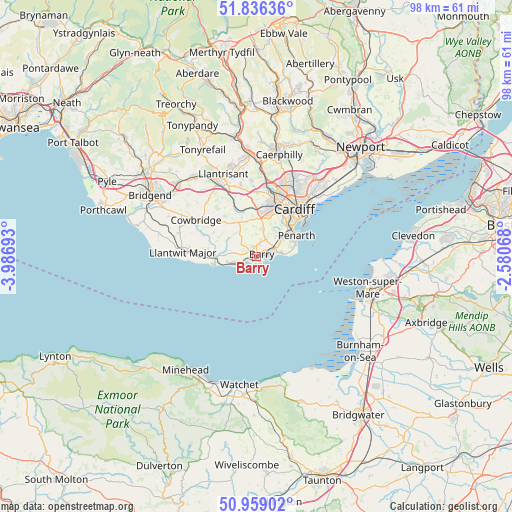
Barry GPS coordinates[2]
51° 23' 59.244" North, 3° 17' 1.68" West
| Map corner | latitude | longitude |
|---|---|---|
| Upper-left | 51.83636°, | -3.98693° |
| Center: | 51.39979°, | -3.2838° |
| Lower-right: | 50.95902°, | -2.58068° |
| Map W x H: | 97.6×97.5 km | = 60.6×60.6mi |
| max Lat: | 60.39635° ⇑80.9% North |
| Barry: | 51.39979° |
| min Lat: | ⇓19.1% South 34.60088° |
| min Long | Barry | max Long |
| -7.64133° | -3.2838° | 32.95536° |
| W 20.6%⇐ | ⇒79.4% E |
Elevation
Elevation of Barry is 25 m = 82 ft, and this is 47.9 m = 157 ft below average elevation for this country.
| Max E: |
515 m = 1690 ft | 76.3% |
| Avg. | 72.9 m = 239 ft | |
| Barry | 25 m = 82 ft | |
Min E: |
-30 m = -98 ft | 23.7% |
See also: Barry elevation on elevation.city.
Geographical zone
Barry is located in North temperate zone (between Tropic of Cancer and the Arctic Circle). Distance of this North polar circle is 1686.1 km =1047.7 mi to North.| Distance of | km | miles | from Barry |
|---|---|---|---|
| North Pole | 4291.9 | 2666.9 | to North |
| Arctic Circle | 1686.1 | 1047.7 | to North |
| Tropic Cancer | 3109.2 | 1932 | to South |
| Equator | 5715.1 | 3551.2 | to South |


Nearby cities:
15 places around Barry: (largest is in red/bold)
• Cardiff
11.5 km =7.1 mi,  38°
38°
• Cowbridge
12.8 km =8 mi,  301°
301°
• Dinas Powys
6.2 km =3.9 mi,  51°
51°
• Llangan
17.9 km =11.1 mi, 302°
• Llanharry
16.4 km =10.2 mi,  321°
321°
• Llantrisant
16.8 km =10.4 mi,  338°
338°
• Llantwit Fardre
17.5 km =10.9 mi,  348°
348°
• Llantwit Major
14.1 km =8.8 mi,  274°
274°
• Penarth
8.8 km =5.5 mi,  60°
60°
• Penllyn
15.9 km =9.9 mi, 301°
• Pentyrch
14.4 km =8.9 mi,  356°
356°
• Pontyclun
15.5 km =9.6 mi,  331°
331°
• Radyr
13.3 km =8.3 mi,  7°
7°
• Rhoose
5.1 km =3.2 mi,  255°
255°
• Wenvoe
5.5 km =3.4 mi, 14°
Sources, notices
• [Note1] Compared only with cities in United Kingdom existing in our database
• [Src1] Map data: © OpenStreetMap contributors (CC-BY-SA)
• [Src2] Other city data from geonames.org with taken over terms of usage.
• [Src3] Geographical zone / Annual Mean Temperature by Robert A. Rohde @ Wikipedia
