Barnsley geodata
Barnsley (England) is a seat of a second-order administrative division; located in United Kingdom in Europe/London (GMT+1) time zone. With population of 71,447 people, there are 149 cities with bigger population in this country. Compared to other cities in United Kingdom, 70.8% of cities are located further ↓South; 55.8% of cities are located further ←West and 77.7% of cities have lower elevation than Barnsley. Note1


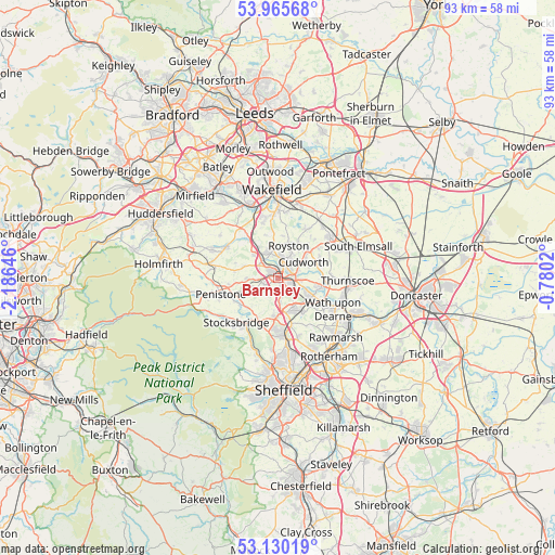
Barnsley GPS coordinates[2]
53° 33' 0" North, 1° 28' 59.988" West
| Map corner | latitude | longitude |
|---|---|---|
| Upper-left | 53.96568°, | -2.18646° |
| Center: | 53.55°, | -1.48333° |
| Lower-right: | 53.13019°, | -0.7802° |
| Map W x H: | 92.9×92.9 km | = 57.7×57.7mi |
| max Lat: | 60.39635° ⇑29.2% North |
| Barnsley: | 53.55° |
| min Lat: | ⇓70.8% South 34.60088° |
| min Long | Barnsley | max Long |
| -7.64133° | -1.48333° | 32.95536° |
| W 55.8%⇐ | ⇒44.2% E |
Elevation
Elevation of Barnsley is 112 m = 367 ft, and this is 39.1 m = 128 ft above average elevation for this country.
| Max E: |
515 m = 1690 ft | 22.3% |
| Barnsley | 112 m 367 ft | |
| Avg. | 72.9 m = 239 ft | |
Min E: |
-30 m = -98 ft | 77.7% |
See also: Barnsley elevation on elevation.city.
Geographical zone
Barnsley is located in North temperate zone (between Tropic of Cancer and the Arctic Circle). Distance of this North polar circle is 1447 km =899.1 mi to North.| Distance of | km | miles | from Barnsley |
|---|---|---|---|
| North Pole | 4052.9 | 2518.4 | to North |
| Arctic Circle | 1447 | 899.1 | to North |
| Tropic Cancer | 3348.3 | 2080.5 | to South |
| Equator | 5954.2 | 3699.8 | to South |


Nearby cities:
15 places around Barnsley: (largest is in red/bold)
• Birdwell
4 km =2.5 mi,  176°
176°
• Cawthorne
6.2 km =3.9 mi,  287°
287°
• Cudworth
5 km =3.1 mi,  61°
61°
• Darfield
7.3 km =4.5 mi,  104°
104°
• Darton
5 km =3.1 mi,  325°
325°
• Dodworth
3 km =1.9 mi,  255°
255°
• Grimethorpe
7.6 km =4.7 mi,  67°
67°
• Hoyland Nether
6 km =3.7 mi,  158°
158°
• Notton
7 km =4.3 mi,  5°
5°
• Royston
6 km =3.7 mi,  21°
21°
• Shafton
6.8 km =4.2 mi,  45°
45°
• Silkstone
5.3 km =3.3 mi,  267°
267°
• Stainborough
3.5 km =2.2 mi,  220°
220°
• Wombwell
6.5 km =4 mi,  118°
118°
• Woolley
7.3 km =4.5 mi,  343°
343°
Sources, notices
• [Note1] Compared only with cities in United Kingdom existing in our database
• [Src1] Map data: © OpenStreetMap contributors (CC-BY-SA)
• [Src2] Other city data from geonames.org with taken over terms of usage.
• [Src3] Geographical zone / Annual Mean Temperature by Robert A. Rohde @ Wikipedia
