Bamford geodata
Bamford (England) is a populated place; located in United Kingdom in Europe/London (GMT+1) time zone. With population of 859 people, there are 3902 cities with bigger population in this country. Compared to other cities in United Kingdom, 66.8% of cities are located further ↓South; 51.2% of cities are located further ←West and 94.7% of cities have lower elevation than Bamford. Note1
Administrative division(s):
- Level 1: England
- Level 2: Derbyshire
- Level 3: High Peak District
- Level 4: Bamford


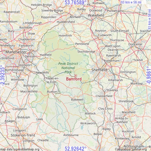
Bamford GPS coordinates[2]
53° 20' 53.592" North, 1° 41' 21.192" West
| Map corner | latitude | longitude |
|---|---|---|
| Upper-left | 53.76589°, | -2.39235° |
| Center: | 53.34822°, | -1.68922° |
| Lower-right: | 52.92642°, | -0.9861° |
| Map W x H: | 93.3×93.3 km | = 58×58mi |
| max Lat: | 60.39635° ⇑33.2% North |
| Bamford: | 53.34822° |
| min Lat: | ⇓66.8% South 34.60088° |
| min Long | Bamford | max Long |
| -7.64133° | -1.68922° | 32.95536° |
| W 51.2%⇐ | ⇒48.8% E |
Elevation
Elevation of Bamford is 181 m = 594 ft, and this is 108.1 m = 355 ft above average elevation for this country.
| Max E: |
515 m = 1690 ft | 5.3% |
| Bamford | 181 m 594 ft | |
| Avg. | 72.9 m = 239 ft | |
Min E: |
-30 m = -98 ft | 94.7% |
See also: United Kingdom elevation on elevation.city.
Geographical zone
Bamford is located in North temperate zone (between Tropic of Cancer and the Arctic Circle). Distance of this North polar circle is 1469.4 km =913 mi to North.| Distance of | km | miles | from Bamford |
|---|---|---|---|
| North Pole | 4075.3 | 2532.3 | to North |
| Arctic Circle | 1469.4 | 913 | to North |
| Tropic Cancer | 3325.8 | 2066.6 | to South |
| Equator | 5931.8 | 3685.8 | to South |


Nearby cities:
15 places around Bamford: (largest is in red/bold)
• Bakewell
15 km =9.3 mi,  176°
176°
• Baslow
12 km =7.5 mi,  158°
158°
• Bradfield
9.6 km =6 mi,  37°
37°
• Chapel en le Frith
15.1 km =9.4 mi,  259°
259°
• Dove Holes
14.3 km =8.9 mi,  247°
247°
• Dronfield
15.1 km =9.4 mi,  109°
109°
• Eyam
7 km =4.3 mi,  173°
173°
• Great Longstone
11.9 km =7.4 mi, 183°
• Hathersage
3.1 km =1.9 mi,  130°
130°
• High Peak
10.6 km =6.6 mi,  281°
281°
• Holmesfield
12.8 km =8 mi,  117°
117°
• Hope
4 km =2.5 mi,  272°
272°
• Hope Valley
3.7 km =2.3 mi, 269°
• Oughtibridge
14 km =8.7 mi,  45°
45°
• Tideswell
9.6 km =6 mi,  215°
215°
Sources, notices
• [Note1] Compared only with cities in United Kingdom existing in our database
• [Src1] Map data: © OpenStreetMap contributors (CC-BY-SA)
• [Src2] Other city data from geonames.org with taken over terms of usage.
• [Src3] Geographical zone / Annual Mean Temperature by Robert A. Rohde @ Wikipedia
